IMAGES TAKEN NEAR TO
Bonsall Street, MANCHESTER, M15 6GR
Introduction
This page details the photographs taken nearby to Bonsall Street, M15 6GR by members of the Geograph project.
The Geograph project started in 2005 with the aim of publishing, organising and preserving representative images for every square kilometre of Great Britain, Ireland and the Isle of Man.

There are currently over 7.5m images from over14,400 individuals and you can help contribute to the project by visiting https://www.geograph.org.uk
Image Map
Images are licensed for reuse under creativecommons.org/licenses/by-sa/2.0
Notes
- Clicking on the map will re-center to the selected point.
- The higher the marker number, the further away the image location is from the centre of the postcode.
Image Listing (77 Images Found)
Images are licensed for reuse under creativecommons.org/licenses/by-sa/2.0
Image
Details
Distance
1
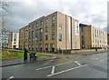
Hulme, Dale
One of several similar accommodation blocks for Manchester Metropolitan University; this one is on Chichester Road.
Image: © Mike Faherty
Taken: 7 Feb 2019
0.05 miles
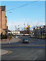
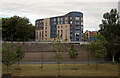
2
Stretford Road (A5067) at its junction with Royce Road, Hulme
Image: © habiloid
Taken: 6 May 2013
0.06 miles
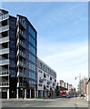
3
Stretford Road
Building on Stretford Road.
Image: © Peter McDermott
Taken: 15 Jul 2018
0.06 miles
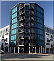
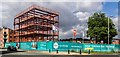
4

Manchester Metropolitan University
New building for Manchester Metropolitan University.
Image: © Peter McDermott
Taken: 15 Feb 2015
0.07 miles
5
Hulme, Ascension Church
Church of England church on Stretford Road: https://www.manchester.anglican.org/acny/church/402/
Image: © Mike Faherty
Taken: 7 Feb 2019
0.07 miles
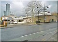
6
Work In Progress
Taken from Hulme High Street at its junction with Old Birley Street and Greenheys Lane West this image shows various high level construction sites. These buildings, including the landmark Hilton/Beetham Tower, have now been completed.
Image: © Marcus Hargis
Taken: 13 Feb 2005
0.08 miles
8
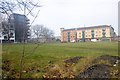
Stretford Road, Hulme
Hulme is an urban regeneration area. The flats on the left were put up in 2006, the building centre right houses a Post Office, take away, off-licence, pharmacist, and, round the corner, a doctors surgery. Between this block and the new flats is the Anglican Parish Church of the Ascension. The library is just up Stretford Road. The green space in the foreground acts as an unofficial park. A dark line running across the image is in fact a footpath. For as long as I have lived in Hulme (four and a half years) this has been used frequently as a public footpath and my understanding is that the practice has been going on for many years previously. For all that there is a road called 'Hulme High Street', this is probably the true centre of the community in Hulme.
Image: © Marcus Hargis
Taken: 5 Feb 2007
0.08 miles
9
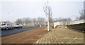
Archway, Arch and Stretford Road buildings
Taken on Archway, the steps to the right mark the start of the footbridge to the Aquarius Estate in Hulme. The Hulme Arch is visible on the right, spanning the A5103 Princess Parkway. The buildings in the background are on Stretford Road.
Image: © Marcus Hargis
Taken: 5 Feb 2007
0.08 miles
10
Birley hall of residence, Manchester Metropolitan University
Part of the Birley Fields campus in Hulme, it is seen here from the other side of Princess Road (A5103).
Image: © habiloid
Taken: 29 Jun 2014
0.09 miles