IMAGES TAKEN NEAR TO
Blanchard Street, MANCHESTER, M15 5PX
Introduction
This page details the photographs taken nearby to Blanchard Street, M15 5PX by members of the Geograph project.
The Geograph project started in 2005 with the aim of publishing, organising and preserving representative images for every square kilometre of Great Britain, Ireland and the Isle of Man.

There are currently over 7.5m images from over14,400 individuals and you can help contribute to the project by visiting https://www.geograph.org.uk
Image Map
Images are licensed for reuse under creativecommons.org/licenses/by-sa/2.0
Notes
- Clicking on the map will re-center to the selected point.
- The higher the marker number, the further away the image location is from the centre of the postcode.
Image Listing (61 Images Found)
Images are licensed for reuse under creativecommons.org/licenses/by-sa/2.0
Image
Details
Distance
1
Construction on Boston Street
These houses have now been built and are occupied.
Image: © Marcus Hargis
Taken: 30 Oct 2004
0.04 miles
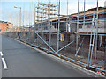
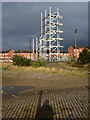
2
Junctions
Taken from Blanchard Street, towards the junction of Old Birley Street, Greenheys Lane West and Hulme High Street. The building under construction is the 'pork pie' round block of flats, now completed.
Image: © Marcus Hargis
Taken: 13 Feb 2005
0.05 miles
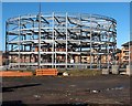
3
Foundations of the 'Life Buildings'
The area has now been built on.
Image: © Marcus Hargis
Taken: 26 Sep 2004
0.05 miles
4
The 'Pork Pie' Building Under Construction
Now completed, this is a block of flats built in the round and resembling in shape a pork pie. Situated on Hulme High Street, this view is no longer possible due to further construction.
Image: © Marcus Hargis
Taken: 13 Feb 2005
0.06 miles
5
Life Buildings Tower
Taken from the ASDA Car Park. This particular view is no longer possible due to further development where the foreground is in the image.
Image: © Marcus Hargis
Taken: 26 Sep 2004
0.06 miles
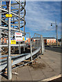
6
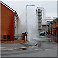
The Hulme Fountain!!!
Image taken from Mytton Street at the junction with and looking down Blanchard Street towards Hulme High Street. The fountain was temporary!
Image: © Marcus Hargis
Taken: 12 Apr 2006
0.07 miles
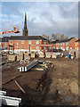
7
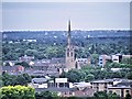
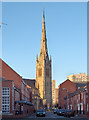
St Mary's Church, Hulme
The spire of St Mary's is still a prominent landmark on the South Manchester skyline even though it is no longer used as a church. See Image] for a ground level view.
Image: © David Dixon
Taken: 4 Jul 2014
0.07 miles
9
Landmark Spire
The church building formerly housing the St Mary's Church of England congregation remains as a significant landmark. However, it is now in the process of being turned into apartments. This has taken a very long time (several years) and the building remains unoccupied to date. The foreground shows houses along Rook Street in Hulme, Manchester. In the background are tower blocks which are not in Manchester at all, but Old Trafford!
Image: © Marcus Hargis
Taken: 19 Dec 2004
0.07 miles
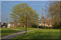
10
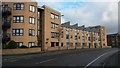
Modern apartment block in Chichester Road South
Image: © David Martin
Taken: 16 Feb 2017
0.07 miles