IMAGES TAKEN NEAR TO
Chichester Road, MANCHESTER, M15 5PB
Introduction
This page details the photographs taken nearby to Chichester Road, M15 5PB by members of the Geograph project.
The Geograph project started in 2005 with the aim of publishing, organising and preserving representative images for every square kilometre of Great Britain, Ireland and the Isle of Man.

There are currently over 7.5m images from over14,400 individuals and you can help contribute to the project by visiting https://www.geograph.org.uk
Image Map
Images are licensed for reuse under creativecommons.org/licenses/by-sa/2.0
Notes
- Clicking on the map will re-center to the selected point.
- The higher the marker number, the further away the image location is from the centre of the postcode.
Image Listing (60 Images Found)
Images are licensed for reuse under creativecommons.org/licenses/by-sa/2.0
Image
Details
Distance
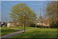
1
Loreto 6th Form College
Well-known RC college.
Image: © Bill Boaden
Taken: 1 Dec 2012
0.02 miles
3
Greenheys Lane West from Loreto College
Image: © Anthony Parkes
Taken: 21 Oct 2012
0.04 miles
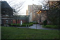
7
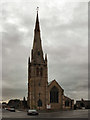
St Mary's Church, Hulme
Grade II listed building, now converted into apartments.
Image: © David Dixon
Taken: 13 Jul 2010
0.06 miles
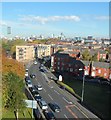
8
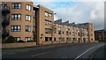
Modern apartment block in Chichester Road South
Image: © David Martin
Taken: 16 Feb 2017
0.06 miles
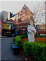
9
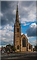
St Mary's Church
St Mary's Church in Hulme, Manchester.
Image: © Peter McDermott
Taken: 28 Jul 2014
0.07 miles