IMAGES TAKEN NEAR TO
Stretford Road, MANCHESTER, M15 5FY
Introduction
This page details the photographs taken nearby to Stretford Road, M15 5FY by members of the Geograph project.
The Geograph project started in 2005 with the aim of publishing, organising and preserving representative images for every square kilometre of Great Britain, Ireland and the Isle of Man.

There are currently over 7.5m images from over14,400 individuals and you can help contribute to the project by visiting https://www.geograph.org.uk
Image Map
Images are licensed for reuse under creativecommons.org/licenses/by-sa/2.0
Notes
- Clicking on the map will re-center to the selected point.
- The higher the marker number, the further away the image location is from the centre of the postcode.
Image Listing (76 Images Found)
Images are licensed for reuse under creativecommons.org/licenses/by-sa/2.0
Image
Details
Distance
1
Hulme, Ascension Church
Church of England church on Stretford Road: https://www.manchester.anglican.org/acny/church/402/
Image: © Mike Faherty
Taken: 7 Feb 2019
0.02 miles
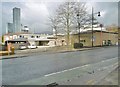
2
Stretford Road
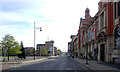
Building on Stretford Road.
Image: © Peter McDermott
Taken: 15 Jul 2018
0.03 miles
3
Stretford Road (A5067) at its junction with Royce Road, Hulme
Image: © habiloid
Taken: 6 May 2013
0.04 miles
4
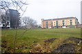
Stretford Road, Hulme
Hulme is an urban regeneration area. The flats on the left were put up in 2006, the building centre right houses a Post Office, take away, off-licence, pharmacist, and, round the corner, a doctors surgery. Between this block and the new flats is the Anglican Parish Church of the Ascension. The library is just up Stretford Road. The green space in the foreground acts as an unofficial park. A dark line running across the image is in fact a footpath. For as long as I have lived in Hulme (four and a half years) this has been used frequently as a public footpath and my understanding is that the practice has been going on for many years previously. For all that there is a road called 'Hulme High Street', this is probably the true centre of the community in Hulme.
Image: © Marcus Hargis
Taken: 5 Feb 2007
0.04 miles
7
Stretford Road (A5067), Hulme
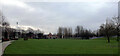
Hulme Park is on the left.
Image: © habiloid
Taken: 6 May 2013
0.06 miles
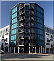
8
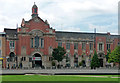
Zion Arts Centre, Stretford Road, Manchester
Built as a Congregational church in 1911, and converted in 1999 by MBLC. The style is a brand of Edwardian Baroque in red brick and stone, with a large Venetian window above the entrance.
As well as a theatre, the centre offers dance, drama and related courses to local people.
Across the road is Hulme Park.
Image: © Stephen Richards
Taken: 25 Jul 2011
0.07 miles
9
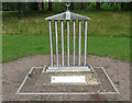
Sculpture, Stretford Road, Manchester
In Hulme Park. Unveiled in 2007 to mark the site of Rolls Royce's original factory, "inspired by the memories of local people, many of whom worked at the factory."
Image: © Stephen Richards
Taken: 25 Jul 2011
0.07 miles
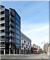
10
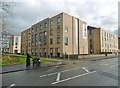
Hulme, Dale
One of several similar accommodation blocks for Manchester Metropolitan University; this one is on Chichester Road.
Image: © Mike Faherty
Taken: 7 Feb 2019
0.07 miles