IMAGES TAKEN NEAR TO
Rolls Crescent, MANCHESTER, M15 5FT
Introduction
This page details the photographs taken nearby to Rolls Crescent, M15 5FT by members of the Geograph project.
The Geograph project started in 2005 with the aim of publishing, organising and preserving representative images for every square kilometre of Great Britain, Ireland and the Isle of Man.

There are currently over 7.5m images from over14,400 individuals and you can help contribute to the project by visiting https://www.geograph.org.uk
Image Map
Images are licensed for reuse under creativecommons.org/licenses/by-sa/2.0
Notes
- Clicking on the map will re-center to the selected point.
- The higher the marker number, the further away the image location is from the centre of the postcode.
Image Listing (46 Images Found)
Images are licensed for reuse under creativecommons.org/licenses/by-sa/2.0
Image
Details
Distance
1
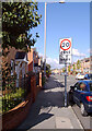
Speed limit sign, Yew Street, Hulme, Manchester
Image: © habiloid
Taken: 29 Jul 2007
0.08 miles
2
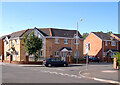
Junction of Rolls Crescent and Yew Street, Hulme, Manchester
Image: © habiloid
Taken: 29 Jul 2007
0.08 miles
4
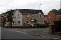
Junction of Yew Street and Rolls Crescent, Hulme, Manchester
Image: © habiloid
Taken: 29 Jun 2014
0.08 miles
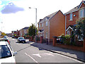
5
Yew Street, Hulme
Yew Street at its junction with Rolls Crescent.
Image: © habiloid
Taken: 5 Aug 2019
0.08 miles
9
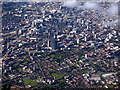
Manchester from the air
Looking over Hulme towards the city centre from above Northenden (4 miles south) from a Prague bound flight from Manchester. The A57(M) road marks the clear boundary between city and suburb.
Image: © Thomas Nugent
Taken: 6 Jul 2020
0.14 miles
10
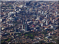
Manchester from the air
Looking over Hulme towards the city centre from above Northenden (4 miles south) from a Prague bound flight from Manchester. The A57(M) road marks the clear boundary between city and suburb.
Image: © Thomas Nugent
Taken: 6 Jul 2020
0.14 miles