IMAGES TAKEN NEAR TO
Rockdove Avenue, MANCHESTER, M15 5EH
Introduction
This page details the photographs taken nearby to Rockdove Avenue, M15 5EH by members of the Geograph project.
The Geograph project started in 2005 with the aim of publishing, organising and preserving representative images for every square kilometre of Great Britain, Ireland and the Isle of Man.

There are currently over 7.5m images from over14,400 individuals and you can help contribute to the project by visiting https://www.geograph.org.uk
Image Map
Images are licensed for reuse under creativecommons.org/licenses/by-sa/2.0
Notes
- Clicking on the map will re-center to the selected point.
- The higher the marker number, the further away the image location is from the centre of the postcode.
Image Listing (150 Images Found)
Images are licensed for reuse under creativecommons.org/licenses/by-sa/2.0
Image
Details
Distance
1
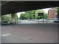
Princess Road ending under Mancunian Way
Image: © Colin Pyle
Taken: 21 May 2010
0.05 miles
3
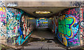
Subway
Subway beneath the A57(M)/A5103 Interchange.
Image: © Peter McDermott
Taken: 13 Apr 2015
0.07 miles
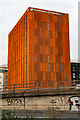
4
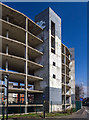
River Street Project
This stalled apartment building which is currently used as a car park is the site of a planned new 40 story hotel and apartment building.
Image: © Peter McDermott
Taken: 5 Apr 2015
0.08 miles
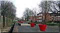
6
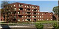
Development
Newly constructed flats.
Image: © Peter McDermott
Taken: 7 May 2018
0.09 miles
7

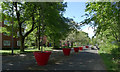
Princess Way
Autumn colours on Princes Way.
Image: © Peter McDermott
Taken: 4 Nov 2018
0.09 miles
8
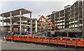
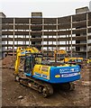
River Street Project
Demolition starts on the new 'River Street Project' development.
Image: © Peter McDermott
Taken: 1 Nov 2015
0.09 miles
10
River Street Project
Work on the River Street Project.
Image: © Peter McDermott
Taken: 2 Apr 2018
0.10 miles