IMAGES TAKEN NEAR TO
Cornbrook Arches, MANCHESTER, M15 4WD
Introduction
This page details the photographs taken nearby to Cornbrook Arches, M15 4WD by members of the Geograph project.
The Geograph project started in 2005 with the aim of publishing, organising and preserving representative images for every square kilometre of Great Britain, Ireland and the Isle of Man.

There are currently over 7.5m images from over14,400 individuals and you can help contribute to the project by visiting https://www.geograph.org.uk
Image Map
Images are licensed for reuse under creativecommons.org/licenses/by-sa/2.0
Notes
- Clicking on the map will re-center to the selected point.
- The higher the marker number, the further away the image location is from the centre of the postcode.
Image Listing (229 Images Found)
Images are licensed for reuse under creativecommons.org/licenses/by-sa/2.0
Image
Details
Distance
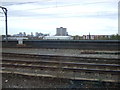
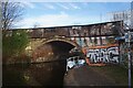
2
St Georges, road bridge
Stone-built bridge carrying Cornbrook Road over the Bridgewater Canal.
Image: © Mike Faherty
Taken: 31 Aug 2009
0.02 miles
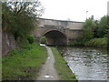
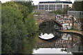
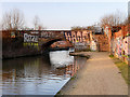
3
Cornbrook Bridge
Cornbrook Bridge over the Bridgewater Canal.
Image: © Peter McDermott
Taken: 27 Nov 2016
0.02 miles

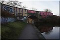
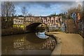
10
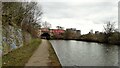
Cornbrook Bridge
On the Bridgewater Canal but with access from the towpath on to the bridge now closed off.
Image: © Kevin Waterhouse
Taken: 28 Feb 2023
0.02 miles