IMAGES TAKEN NEAR TO
Waterways Avenue, MANCHESTER, M15 4RR
Introduction
This page details the photographs taken nearby to Waterways Avenue, M15 4RR by members of the Geograph project.
The Geograph project started in 2005 with the aim of publishing, organising and preserving representative images for every square kilometre of Great Britain, Ireland and the Isle of Man.

There are currently over 7.5m images from over14,400 individuals and you can help contribute to the project by visiting https://www.geograph.org.uk
Image Map
Images are licensed for reuse under creativecommons.org/licenses/by-sa/2.0
Notes
- Clicking on the map will re-center to the selected point.
- The higher the marker number, the further away the image location is from the centre of the postcode.
Image Listing (242 Images Found)
Images are licensed for reuse under creativecommons.org/licenses/by-sa/2.0
Image
Details
Distance
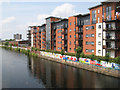
1
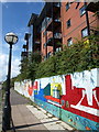
Mural, Steele House
Smart flats overlooking the Irwell, with a bright mural along the towpath.
Image: © Derek Harper
Taken: 19 Aug 2010
0.02 miles
2
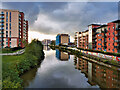
Manchester Ship Canal (River Irwell) at Pomona Wharf
A view looking downstream (towards the former docks at Salford Quays) from the Woden Street footbridge.
Image: © David Dixon
Taken: 2 Nov 2021
0.02 miles
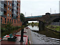
3
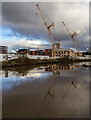
Bridgewater Canal
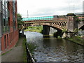
Development alongside the Bridgewater Canal.
Image: © Peter McDermott
Taken: 27 Nov 2016
0.02 miles
4
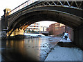
Cast-iron span
The cast-iron span of the original Manchester, South Junction & Altrincham Railway bridge crosses the frozen Bridgewater Canal as it approaches St. George's.
Image: © Jonathan Wilkins
Taken: 19 Dec 2010
0.03 miles
5
Canoe on the Canal
Good views along here from the tramline which is on a viaduct.
Image: © Des Blenkinsopp
Taken: 30 Jun 2018
0.04 miles
6
Cornbrook viaducts
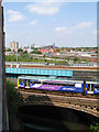
Parallel viaducts carry the Metrolink and railway across the Bridgewater Canal at Cornbrook. The Metrolink viaduct was originally built by the Cheshire Lines Committee in 1880, and comprises plate and lattice girders. Such modern materials were not available to the Manchester South Junction and Altrincham Railway in 1849 when they built their traditional and beautiful cast-iron single span. The train is a class 142 'Pacer' DMU operated by Northern Rail.
The image was captured from a balcony on Mere House.
Image: © Jonathan Wilkins
Taken: 27 Jun 2010
0.04 miles
7
Irwell Path
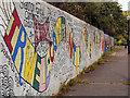
The foot and cycle path along the River Irwell/Manchester Ship Canal has been brightened by this mural painted, in 1999, by volunteers on the Irwell Community Project.
Image: © David Dixon
Taken: 1 Oct 2012
0.04 miles
8
St Georges, railway bridges
Bridges over the Bridgewater Canal: the nearer, rail, the further, Metro.
Image: © Mike Faherty
Taken: 31 Aug 2009
0.04 miles
9
Irwell-side apartments
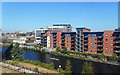
A large development of apartments on Worrall Street which face, or back onto the River Irwell with its graffiti-rich towpath wall. Support is being shown for the (doomed) English soccer team whose match against Germany kicked off a couple of hours after the image was captured. It is extraordinary how buildings such as this are now sought-after in an area that was utterly derelict in the years following the cessation of trade in the docks.
Image: © Jonathan Wilkins
Taken: 27 Jun 2010
0.04 miles
10
Near Hulme Hall
The bridges carry the Metrolink routes to Altrincham and Eccles as well as the railway to Altrincham and beyond.
Image: © Alan Murray-Rust
Taken: 18 Sep 2009
0.04 miles