IMAGES TAKEN NEAR TO
Blantyre Street, MANCHESTER, M15 4LG
Introduction
This page details the photographs taken nearby to Blantyre Street, M15 4LG by members of the Geograph project.
The Geograph project started in 2005 with the aim of publishing, organising and preserving representative images for every square kilometre of Great Britain, Ireland and the Isle of Man.

There are currently over 7.5m images from over14,400 individuals and you can help contribute to the project by visiting https://www.geograph.org.uk
Image Map
Images are licensed for reuse under creativecommons.org/licenses/by-sa/2.0
Notes
- Clicking on the map will re-center to the selected point.
- The higher the marker number, the further away the image location is from the centre of the postcode.
Image Listing (545 Images Found)
Images are licensed for reuse under creativecommons.org/licenses/by-sa/2.0
Image
Details
Distance
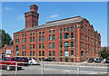
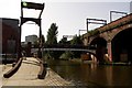
1
Worsley Mill
Worsley Mill alongside the Mancunian Way and the Bridgewater Canal.
Image: © Peter McDermott
Taken: 25 Aug 2018
0.01 miles
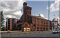
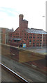
2
Former mill, Egerton Street, Manchester
Impressive former flour mill by William Waddington, 1896. Good tower and much corbelling throughout. Grade II listed.
Now known as Worsley Mill (which may not have any historical basis) and converted to offices.
Image: © Stephen Richards
Taken: 17 Aug 2016
0.01 miles
3
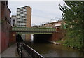
The Bridgewater Canal goes under the A57
This bridge carries the Manchester inner ring road.
Image: © Bill Boaden
Taken: 4 Sep 2010
0.01 miles
4
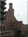
Worsley Mill
Former factory alongside the Bridgewater Canal in the Castlefield area. The bridge crosses the access into the factory.
Image: © Alan Murray-Rust
Taken: 18 Sep 2009
0.01 miles
5
Worsley Mill from Tramline Bridge over A57
https://manchesterhistory.net/manchester/outside/worsley.html
Image: © Philip Cornwall
Taken: 4 Aug 2012
0.02 miles
6
![Small canal basin, east of Egerton Road bridge [no 100]](https://s3.geograph.org.uk/geophotos/06/87/63/6876391_90a23fe5_120x120.jpg)
Small canal basin, east of Egerton Road bridge [no 100]
A boater's view. In 1915 this served the Canal Flour Mills.
Image: © Christine Johnstone
Taken: 22 May 2021
0.02 miles
7

Bridgewater Canal and former Canal Flour Mills
The mills are this side of the road bridge. Since this view they have become a grade II listed building. However, the large rectangular block beyond the bridge has been demolished and the site redeveloped.
Image: © Robin Webster
Taken: 18 Sep 1990
0.02 miles
9
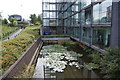
Converted loading dock
This was formerly built for moving goods between warehouses and the canal, but it has become a water feature for the new apartments.
Image: © Bill Boaden
Taken: 4 Sep 2010
0.03 miles
10
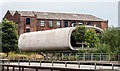
Tubular Building
Tubular Building alongside the Mancunian Way. For a view of the building back in 2011 see David Dixon's photograph - Image
Image: © Peter McDermott
Taken: 19 Jul 2014
0.03 miles