IMAGES TAKEN NEAR TO
Hulme Hall Road, MANCHESTER, M15 4LA
Introduction
This page details the photographs taken nearby to Hulme Hall Road, M15 4LA by members of the Geograph project.
The Geograph project started in 2005 with the aim of publishing, organising and preserving representative images for every square kilometre of Great Britain, Ireland and the Isle of Man.

There are currently over 7.5m images from over14,400 individuals and you can help contribute to the project by visiting https://www.geograph.org.uk
Image Map
Images are licensed for reuse under creativecommons.org/licenses/by-sa/2.0
Notes
- Clicking on the map will re-center to the selected point.
- The higher the marker number, the further away the image location is from the centre of the postcode.
Image Listing (252 Images Found)
Images are licensed for reuse under creativecommons.org/licenses/by-sa/2.0
Image
Details
Distance
2
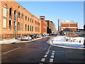
Ellesmere Street
Brick-built warehouses have been converted for residential and commercial use.
Image: © Jonathan Wilkins
Taken: 19 Dec 2010
0.03 miles
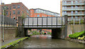
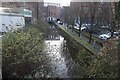
3
Bridgewater Canal towards Hulme Hall Road Bridge
Image: © Ian S
Taken: 1 Mar 2022
0.03 miles
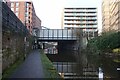
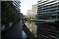
5
Basin on Bridgewater Canal near Hulme Hall Road Bridge
Image: © Ian S
Taken: 1 Mar 2022
0.03 miles
6
Bridgewater Canal towards Hulme Hall Road Bridge
Image: © Ian S
Taken: 1 Mar 2022
0.03 miles
7
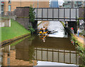
Waxi on the Bridgewater Canal
"Waxi" (water taxi https://www.manchesterwatertaxis.com/ ) under the bridge at Hulme Hall Road. The Manchester Water Taxis provide a passenger service between the Castlefield Basin and Salford Quays, Old Trafford and the Trafford Centre, along the Bridgewater Canal.
Image: © David Dixon
Taken: 4 Sep 2017
0.03 miles
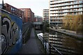
8
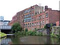
Bridgewater canal and derelict buildings
This landscape is being steadily erased and replaced with modern apartments.
Image: © David Martin
Taken: 1 Aug 2010
0.03 miles
9
![Private canal basin, east of Hulme Hall Road bridge [no 99]](https://s1.geograph.org.uk/geophotos/06/87/63/6876381_0cd51c5c_120x120.jpg)
Private canal basin, east of Hulme Hall Road bridge [no 99]
A boater's view. In 1915 there were three mills around this basin - a cotton mill, Talbot Mills [cotton and braid] and Britannia Emery Mills
Image: © Christine Johnstone
Taken: 22 May 2021
0.04 miles
10
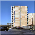
Saint George's Island
Two of the apartments in the St George’s Island development at Castlefield.
The St George Island apartments sit on a promontory of land close to where the Hulme Locks Junction Canal once formed an important connection between the Bridgewater Canal and the River Irwell / Manchester Ship Canal. The complex includes 5 apartment buildings set within almost two acres of land between the Railway Viaduct and the canal. A footbridge and a road bridge (Hulme Hall Road, from where this photograph was taken) provide access onto the site. http://manchesterhistory.net/manchester/outside.html - Manchester History Net
Image: © David Dixon
Taken: 1 Feb 2012
0.04 miles