IMAGES TAKEN NEAR TO
Kelso Place, MANCHESTER, M15 4GT
Introduction
This page details the photographs taken nearby to Kelso Place, M15 4GT by members of the Geograph project.
The Geograph project started in 2005 with the aim of publishing, organising and preserving representative images for every square kilometre of Great Britain, Ireland and the Isle of Man.

There are currently over 7.5m images from over14,400 individuals and you can help contribute to the project by visiting https://www.geograph.org.uk
Image Map
Images are licensed for reuse under creativecommons.org/licenses/by-sa/2.0
Notes
- Clicking on the map will re-center to the selected point.
- The higher the marker number, the further away the image location is from the centre of the postcode.
Image Listing (258 Images Found)
Images are licensed for reuse under creativecommons.org/licenses/by-sa/2.0
Image
Details
Distance
1
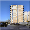
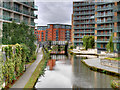
Saint George's Island
Two of the apartments in the St George’s Island development at Castlefield.
The St George Island apartments sit on a promontory of land close to where the Hulme Locks Junction Canal once formed an important connection between the Bridgewater Canal and the River Irwell / Manchester Ship Canal. The complex includes 5 apartment buildings set within almost two acres of land between the Railway Viaduct and the canal. A footbridge and a road bridge (Hulme Hall Road, from where this photograph was taken) provide access onto the site. http://manchesterhistory.net/manchester/outside.html - Manchester History Net
Image: © David Dixon
Taken: 1 Feb 2012
0.02 miles
2
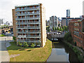
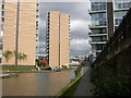
St. George's Island
A development of apartments on the land between the Bridgewater Canal and the railway lines. Appropriate and patriotic flags were being flown for the World Cup soccer. Derelict canalside warehouses can be seen on the towpath side of the canal, indicating what a run-down area this had become before the present enthusiasm for urban apartments, which is very welcome.
Image: © Jonathan Wilkins
Taken: 27 Jun 2010
0.02 miles
3
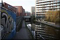
Bridgewater Canal towards Hulme Hall Road Bridge
Image: © Ian S
Taken: 1 Mar 2022
0.02 miles
4
Railway Viaduct, St Georges 2003
Now a developed area, St Georges Island / Kelso Place as seen in 2003.
Image: © Phill
Taken: 1 Jun 2003
0.02 miles
5
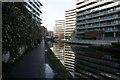
Bridgewater Canal towards Hulme Hall Road Bridge
Image: © Ian S
Taken: 1 Mar 2022
0.02 miles
6
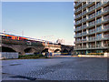
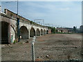
Railway Viaduct
The railway viaduct behind the St George's Island apartment complex on a small promontory of land between the railway and the Bridgewater Canal, close to where the Hulme Locks Junction Canal once formed an important connection between the Bridgewater Canal and the River Irwell/Manchester Ship Canal.
Image: © David Dixon
Taken: 1 Feb 2012
0.03 miles
8
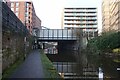
Footbridge
A footbridge leading to new apartment blocks beside the canal
Image: © R lee
Taken: 3 Aug 2007
0.03 miles
9
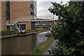
Bridgewater Canal, St George's Island
Modern, high-rise apartment blocks line both sides of the canal at St George's Island.
Image: © David Dixon
Taken: 4 Sep 2017
0.03 miles
10
Cornbrook, canalside housing
Apartment blocks alongside the Bridgewater Canal; entrance to a basin to the right, and Metro trains on the viaduct above, currently out of use because of maintenance work.
Image: © Mike Faherty
Taken: 31 Aug 2009
0.03 miles