IMAGES TAKEN NEAR TO
Blantyre Street, MANCHESTER, M15 4EG
Introduction
This page details the photographs taken nearby to Blantyre Street, M15 4EG by members of the Geograph project.
The Geograph project started in 2005 with the aim of publishing, organising and preserving representative images for every square kilometre of Great Britain, Ireland and the Isle of Man.

There are currently over 7.5m images from over14,400 individuals and you can help contribute to the project by visiting https://www.geograph.org.uk
Image Map
Images are licensed for reuse under creativecommons.org/licenses/by-sa/2.0
Notes
- Clicking on the map will re-center to the selected point.
- The higher the marker number, the further away the image location is from the centre of the postcode.
Image Listing (592 Images Found)
Images are licensed for reuse under creativecommons.org/licenses/by-sa/2.0
Image
Details
Distance
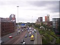
3
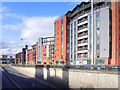
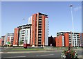
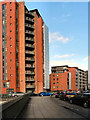
City Gate
City Gate is a complex of three large apartment blocks adjacent to the Mancunian Way in Castlefield. More information at http://manchesterhistory.net/manchester/outside/citygates.html (Manchester History net)
The Mancunian Way (A57) is unusually empty in this picture. That is because it had been closed for the day whilst contractors carried out maintenance on it.
Image: © David Dixon
Taken: 16 Oct 2011
0.01 miles
4
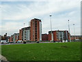
City Gate, Manchester
City Gate is a complex of three large apartment blocks adjacent to the Mancunian Way in Castlefield. The apartments wrap around north west corner of the roundabout where the Mancunian Way passes under Chester Road.
More information at http://manchesterhistory.net/manchester/outside/citygates.html (Manchester History net)
Image: © David Dixon
Taken: 16 Oct 2011
0.02 miles
5
The A57(M) viewed from a passing Metrolink tram
Image: © Raymond Knapman
Taken: 24 Jun 2011
0.03 miles

7
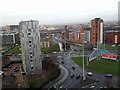
Roundabout From the Roof of Hulme Court
From roof of Hulme Court from roof of lift and plant room. It shows the roundabout with clockwise from 7 o'clock - Chorlton Road; Chester Road; Mancunian Way emerging from underpass and roundabout exit to Deansgate / Knott Mill.
Image: © Anthony Parkes
Taken: 18 Jan 2012
0.05 miles
8
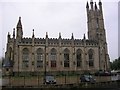
St George's
Another view of this former church, now apartments. Close to the western end of the Mancunian Way, near Hulme.
Image: © Keith Williamson
Taken: 28 Sep 2005
0.06 miles
9
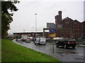
Wet Day in Manchester!
A view westwards at the end of the Mancunian Way at the corner of Ellesmere Street.
Image: © Keith Williamson
Taken: 28 Sep 2005
0.06 miles
10
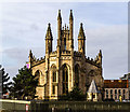
St George's Church
St George's Church which has been converted into flats.
Image: © Peter McDermott
Taken: 11 Mar 2018
0.06 miles