IMAGES TAKEN NEAR TO
Millington Walk, MANCHESTER, M15 4DF
Introduction
This page details the photographs taken nearby to Millington Walk, M15 4DF by members of the Geograph project.
The Geograph project started in 2005 with the aim of publishing, organising and preserving representative images for every square kilometre of Great Britain, Ireland and the Isle of Man.

There are currently over 7.5m images from over14,400 individuals and you can help contribute to the project by visiting https://www.geograph.org.uk
Image Map
Images are licensed for reuse under creativecommons.org/licenses/by-sa/2.0
Notes
- Clicking on the map will re-center to the selected point.
- The higher the marker number, the further away the image location is from the centre of the postcode.
Image Listing (19 Images Found)
Images are licensed for reuse under creativecommons.org/licenses/by-sa/2.0
Image
Details
Distance
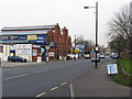
2
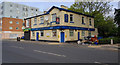
The Three Legs of Man
The Three Legs of Man public house.
Image: © Peter McDermott
Taken: 16 May 2020
0.14 miles
3
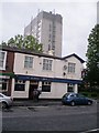
Stretford Road (nr Three Legs of Man pub) - 26-5-2011
Image: © Duncan Watts
Taken: 26 May 2011
0.14 miles
4
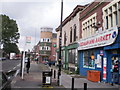
Stretford Road, Manchester
The stretch of Stretford Road near the old Platford pub - now closed
Image: © Duncan Watts
Taken: 26 May 2011
0.16 miles
5
Stretford Road (Platford pub) - 26-5-2011
Platford pub - yet another pub closed
Image: © Duncan Watts
Taken: 26 May 2011
0.17 miles
6
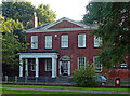
10 Princess Street, Manchester
The pick of the smattering of Georgian houses in and around Chester Road, this was built c1807 as one of a pair for mill-owner, John Pooley. Grade II listed.
It was later incorporated into Hulme Barracks, built in 1817 and demolished about a century later. Now flats.
Image: © Stephen Richards
Taken: 17 Aug 2016
0.18 miles
7
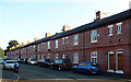
Barrack Street, Manchester
One of few reminders of Hulme Barracks, built in 1817 and demolished about a century later - these were built in the early C20th for NCOs. Contrary to appearances they are flats, split between ground and first floors, with access via paired doors, "an unusual configuration in Manchester, though common in Tyneside". Similar houses survive on the parallel St George's Avenue.
Image: © Stephen Richards
Taken: 17 Aug 2016
0.19 miles
9
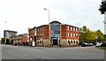
Chester Road, St George's
215-219 Chester Road is the offices of Charted Accountants Beever and Struthers http://www.beeverstruthers.co.uk/aboutus Their address is listed as St George's House - not to be confused with St George's House, Peter Street Image However the name above the door is St George's Court which appears to be the name also given to one of the high-rise blocks of apartments on Angela Street which is just visible in the background.
Image: © Gerald England
Taken: 17 Oct 2015
0.24 miles
10
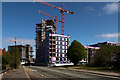
Cornbrook Works
The Cornbrook Works development site.
Image: © Peter McDermott
Taken: 13 Apr 2020
0.24 miles