IMAGES TAKEN NEAR TO
Dickinson Street, MANCHESTER, M1 4LX
Introduction
This page details the photographs taken nearby to Dickinson Street, M1 4LX by members of the Geograph project.
The Geograph project started in 2005 with the aim of publishing, organising and preserving representative images for every square kilometre of Great Britain, Ireland and the Isle of Man.

There are currently over 7.5m images from over14,400 individuals and you can help contribute to the project by visiting https://www.geograph.org.uk
Image Map (Loading...)


Getting Data...Please wait
Leaflet Map data © OpenStreetMap
Images are licensed for reuse under creativecommons.org/licenses/by-sa/2.0
Notes
- Clicking on the map will re-center to the selected point.
- The higher the marker number, the further away the image location is from the centre of the postcode.
Image Listing (2384 Images Found)
Images are licensed for reuse under creativecommons.org/licenses/by-sa/2.0
Image
Details
Distance
1
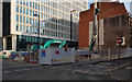
Guardian Underground Telephone Exchange
The surface buildings of the Guardian Underground Telephone Exchange on George Street in Manchester.
Image: © Peter McDermott
Taken: 2 Jul 2016
0.01 miles
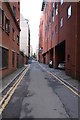
2
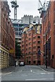
Dickinson Street
Looking North, with the Town Hall Extension in the distance.
The brick built building on the left has for the past two years been rented as offices by the builders of the glass and concrete horror behind it.
Image: © Bob Harvey
Taken: 11 Sep 2019
0.02 miles
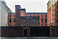
3
Peterloo House, Dickinson Street, Manchester
Large L-shaped 1960s office block, the long front facing George Street, composed of a series of bands, white-brown brick-window, all resting on white pilotis.
Empty at the time of writing, and earmarked for demolition so that a twelve-storey office block can be built. Is it really necessary, given the amount of empty office space in this, and every other, city?
Image: © Stephen Richards
Taken: 25 Jul 2011
0.02 miles
5
Dickinson Street
Dickinson Street in Manchester.
Image: © Peter McDermott
Taken: 10 Jul 2016
0.02 miles
6
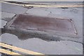
Steel plate, St James' street
A temporary repair, where "temporary" seems to have been several years.
These sort of load-bearing steel sheets are common where a culvert has collapsed, for example, but to see it tarmac'd in is rather an admission of defeat by someone.
Image: © Bob Harvey
Taken: 11 Sep 2019
0.02 miles
7
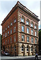
63 George Street, Manchester
One of Manchester's very many excellent palazzo-style warehouses (now offices). Built c1857, possibly by the city's leading exponent, Edward Walters. Red brick with stone dressings, rusticated ground floor, paired windows on the top floor and a heavy cornice. Grade II listed.
On the corner with Dickinson Street, hence its current name, Dickinson House.
Image: © Stephen Richards
Taken: 22 Jun 2011
0.02 miles
8
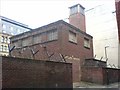
A Cold War legacy
This austere structure is located in central Manchester between George St and St James St. I believe it to be an entrance to the Guardian Exchange. This underground communications bunker was built in the 1950s and was designed to withstand atomic attack on Manchester and preserve regional and national communications links. The development of the H bomb reputedly led to its security being compromised. The bunker and its tunnels are still used to route telecommunications cables under the city. A fire in such a tunnel in 2004 put parts of the telephone network out of action for several days. See also Image and Image
Image: © Keith Williamson
Taken: 30 Apr 2009
0.03 miles