IMAGES TAKEN NEAR TO
Princess Road, MANCHESTER, M14 7LT
Introduction
This page details the photographs taken nearby to Princess Road, M14 7LT by members of the Geograph project.
The Geograph project started in 2005 with the aim of publishing, organising and preserving representative images for every square kilometre of Great Britain, Ireland and the Isle of Man.

There are currently over 7.5m images from over14,400 individuals and you can help contribute to the project by visiting https://www.geograph.org.uk
Image Map
Images are licensed for reuse under creativecommons.org/licenses/by-sa/2.0
Notes
- Clicking on the map will re-center to the selected point.
- The higher the marker number, the further away the image location is from the centre of the postcode.
Image Listing (44 Images Found)
Images are licensed for reuse under creativecommons.org/licenses/by-sa/2.0
Image
Details
Distance
1
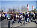
Moss Side Good Friday Walk Crossing Princess Road.
Princess Road is one of the main roads into Manchester. It leads from the city centre south towards the airport, M56 to North Wales, and the M6. Crossing at the Claremont Road lights is easy on the Good Friday walk with church members from nearby churches.
Image: © R Greenhalgh
Taken: 6 Apr 2007
0.05 miles
2
Infusion Homes on Bowes Street in Moss Side, Manchester
Infusion Homes is a housing development in Moss Side, Manchester, constructed in 2011 and consisting of new build and renovated houses. View from Alexandra Park, Whalley Range.
Image: © Stephen Taylor
Taken: 14 Apr 2012
0.05 miles
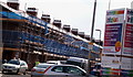
4
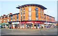
Moss Side, shopping parade
A mixture of old and new premises, on Princess Road; locksmith, post office, butcher, dentist, and ethnic hair salons and food shops.
Image: © Mike Faherty
Taken: 17 Nov 2010
0.06 miles
5
Infusion development on Hartington Street in Moss Side
Infusion housing development on Hartington Street in Moss Side, Manchester
Image: © Stephen Taylor
Taken: 14 Mar 2011
0.06 miles
6
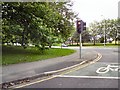
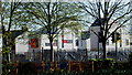
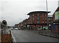
Claremount Road
The corner of Princess Street and Claremount Road
Image: © Gerald England
Taken: 21 Jul 2012
0.06 miles
7
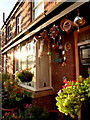
Terrace house on Claremont Road, Moss Side, Manchester
Image: © Stephen Taylor
Taken: 7 Oct 2010
0.07 miles
8

Indifference to the message, Manchester
Despite the committed approach of the placard holder at these traffic lights, he is met with nothing but indifference.
Image: © Matt Harrop
Taken: 16 Sep 2016
0.07 miles
9
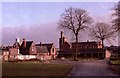
Alexandra Park, Moss Side, Manchester
From this part of Alexandra Park, there are old park buildings within the park on the Left. The white clock tower at the far left is part of the old bus station. Beyond the barn like park buildings on the right of the photo, the large brick building of the Bishop Bilsborrow Memorial School is visible. This school was demolished in 2011. The park entrance is at the extreme right of the photograph. Also see Image] Image] Image] Image]
Image: © Tom Jolliffe
Taken: Unknown
0.09 miles
10
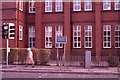
Bishop Bilsborrow Memorial School, Princess Road, Moss Side
A closer view of the classrooms in the Bishop Bilsborrow Memorial School. This school opened in 1909. Please see description of this school in other posted images. School design of this era ensured that the bottom of the windows was relatively high from floor. While this may have been related to safety considerations, it also prevented children from looking out of the windows, except in an upwards direction. The school was demolished in 2011. Also see Image] Image] Image] Image]
Image: © Tom Jolliffe
Taken: Unknown
0.09 miles