IMAGES TAKEN NEAR TO
Westbourne Road, MANCHESTER, M14 6YN
Introduction
This page details the photographs taken nearby to Westbourne Road, M14 6YN by members of the Geograph project.
The Geograph project started in 2005 with the aim of publishing, organising and preserving representative images for every square kilometre of Great Britain, Ireland and the Isle of Man.

There are currently over 7.5m images from over14,400 individuals and you can help contribute to the project by visiting https://www.geograph.org.uk
Image Map
Images are licensed for reuse under creativecommons.org/licenses/by-sa/2.0
Notes
- Clicking on the map will re-center to the selected point.
- The higher the marker number, the further away the image location is from the centre of the postcode.
Image Listing (8 Images Found)
Images are licensed for reuse under creativecommons.org/licenses/by-sa/2.0
Image
Details
Distance

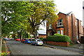
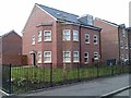
3
Ashlyn Grove, Fallowfield
An area of slightly older residential properties, with many occupied by students.
Image: © Bill Boaden
Taken: 27 Dec 2012
0.13 miles
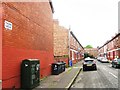
4
Rubbish arrangements
The complexities of bin management in a multi-occupied building...
Image: © David Martin
Taken: 2 Apr 2014
0.15 miles
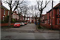
5
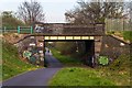
Fallowfield Loop
Bridge carrying Lindleywood Road across the disused railway line, the Fallowfield Loop.
Image: © Peter McDermott
Taken: 20 Apr 2015
0.19 miles
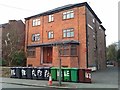
7

Development site in Fallowfield
A valuable site close to the main street in Fallowfield. There used to be one large house on this site which I think was Egerton Lodge. The site appears now to have been bought though no building work has started yet.
Image: © Bill Boaden
Taken: 27 Dec 2012
0.23 miles