IMAGES TAKEN NEAR TO
Amherst Road, MANCHESTER, M14 6UR
Introduction
This page details the photographs taken nearby to Amherst Road, M14 6UR by members of the Geograph project.
The Geograph project started in 2005 with the aim of publishing, organising and preserving representative images for every square kilometre of Great Britain, Ireland and the Isle of Man.

There are currently over 7.5m images from over14,400 individuals and you can help contribute to the project by visiting https://www.geograph.org.uk
Image Map
Images are licensed for reuse under creativecommons.org/licenses/by-sa/2.0
Notes
- Clicking on the map will re-center to the selected point.
- The higher the marker number, the further away the image location is from the centre of the postcode.
Image Listing (24 Images Found)
Images are licensed for reuse under creativecommons.org/licenses/by-sa/2.0
Image
Details
Distance
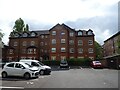
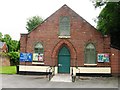
1
Mauldeth Road
Taken from its junction with Amherst Road (part of which can be seen in the foreground).
Image: © Slbs
Taken: Unknown
0.06 miles
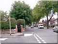
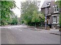
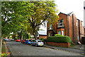
2
Amherst Road, Withington
This is the southern stretch of Amherst Road, looking south from near the junction with Mauldeth Road.
Image: © Slbs
Taken: Unknown
0.11 miles
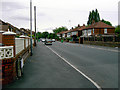
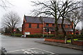
5
Northern end of Amherst Road
Running left to right at the junction is Brook Road, and beyond that is Clifton Avenue.
Image: © Slbs
Taken: Unknown
0.14 miles
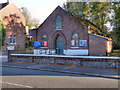
6
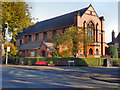
St Chad's Church, Ladybarn
St Chad's Church, on Mauldeth Road, Ladybarn, was founded in 1907.
Image: © David Dixon
Taken: 28 Sep 2011
0.16 miles
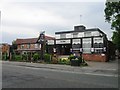
9
St Chad's, Ladybarn
On the junction of Egerton Road and Mauldeth Road.
Image: © Bill Boaden
Taken: 27 Dec 2012
0.18 miles