IMAGES TAKEN NEAR TO
Beaconsfield, MANCHESTER, M14 6UP
Introduction
This page details the photographs taken nearby to Beaconsfield, M14 6UP by members of the Geograph project.
The Geograph project started in 2005 with the aim of publishing, organising and preserving representative images for every square kilometre of Great Britain, Ireland and the Isle of Man.

There are currently over 7.5m images from over14,400 individuals and you can help contribute to the project by visiting https://www.geograph.org.uk
Image Map
Images are licensed for reuse under creativecommons.org/licenses/by-sa/2.0
Notes
- Clicking on the map will re-center to the selected point.
- The higher the marker number, the further away the image location is from the centre of the postcode.
Image Listing (37 Images Found)
Images are licensed for reuse under creativecommons.org/licenses/by-sa/2.0
Image
Details
Distance
6
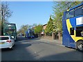
Lots of buses
Morning rush-hour traffic consisting largely of buses.
The blue Magic Bus in the midground was sitting 'out of service' with hazard flashers on in the bus lane.
Image: © Bob Harvey
Taken: 23 Apr 2015
0.14 miles
7
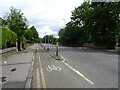
Mauldeth Road
Taken from its junction with Amherst Road (part of which can be seen in the foreground).
Image: © Slbs
Taken: Unknown
0.14 miles
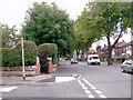
9
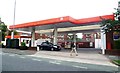
Fuel Filling Station - Wilmslow Road
Image: © Anthony Parkes
Taken: 25 Jul 2012
0.14 miles
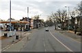
10
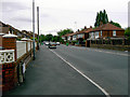
Amherst Road, Withington
This is the southern stretch of Amherst Road, looking south from near the junction with Mauldeth Road.
Image: © Slbs
Taken: Unknown
0.15 miles