IMAGES TAKEN NEAR TO
Heald Place, MANCHESTER, M14 5WJ
Introduction
This page details the photographs taken nearby to Heald Place, M14 5WJ by members of the Geograph project.
The Geograph project started in 2005 with the aim of publishing, organising and preserving representative images for every square kilometre of Great Britain, Ireland and the Isle of Man.

There are currently over 7.5m images from over14,400 individuals and you can help contribute to the project by visiting https://www.geograph.org.uk
Image Map
Images are licensed for reuse under creativecommons.org/licenses/by-sa/2.0
Notes
- Clicking on the map will re-center to the selected point.
- The higher the marker number, the further away the image location is from the centre of the postcode.
Image Listing (27 Images Found)
Images are licensed for reuse under creativecommons.org/licenses/by-sa/2.0
Image
Details
Distance
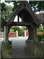
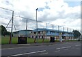
3
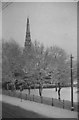
Church in Platt Fields Park.
Taken in the Winter of 1957, before leaving the following June for Australia.
Image: © Frank Airey
Taken: 1 Dec 1957
0.07 miles
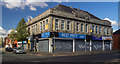
4
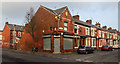
Corner Shop
Disused corner shop on the corner of Wincombe Street and Parkfield Street.
Image: © Peter McDermott
Taken: 15 Feb 2015
0.07 miles
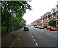
5
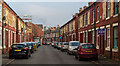
Moss Side
Chilworth Street in Moss Side.
Image: © Peter McDermott
Taken: 15 Feb 2015
0.08 miles
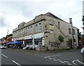
7
Platt Lane
Shops on the corner of Platt Lane and Yew Tree Road.
Image: © Peter McDermott
Taken: 19 Apr 2015
0.11 miles
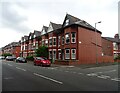
10
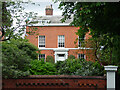
66 Platt Lane, Manchester
One of two houses (with no. 68) built c1830, each with an Ionic porch. Grade II listed.
Image: © Stephen Richards
Taken: 12 Jun 2016
0.13 miles