IMAGES TAKEN NEAR TO
Lower Park Road, MANCHESTER, M14 5RS
Introduction
This page details the photographs taken nearby to Lower Park Road, M14 5RS by members of the Geograph project.
The Geograph project started in 2005 with the aim of publishing, organising and preserving representative images for every square kilometre of Great Britain, Ireland and the Isle of Man.

There are currently over 7.5m images from over14,400 individuals and you can help contribute to the project by visiting https://www.geograph.org.uk
Image Map
Images are licensed for reuse under creativecommons.org/licenses/by-sa/2.0
Notes
- Clicking on the map will re-center to the selected point.
- The higher the marker number, the further away the image location is from the centre of the postcode.
Image Listing (71 Images Found)
Images are licensed for reuse under creativecommons.org/licenses/by-sa/2.0
Image
Details
Distance
1
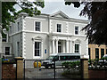
3 Lower Park Road, Manchester
A rich villa built around 1840 with an ornate Ionic portico. Grade II listed.
Now part of Xaverian Sixth Form College.
Image: © Stephen Richards
Taken: 12 Jun 2016
0.03 miles
2
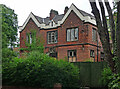
1 Upper Park Road, Manchester
Aka High Elms. Victorian Tudor-Gothic villa. Grade II listed.
Largely boarded up in 2016. By 2023 the only change was that it was completely boarded up.
Image: © Stephen Richards
Taken: 12 Jun 2016
0.07 miles
3
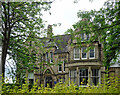
Maryland, Lower Park Road, Manchester
A large eclectic Gothic house built c1870. Grade II listed.
Now part of Xaverian Sixth Form College.
Image: © Stephen Richards
Taken: 12 Jun 2016
0.08 miles
4
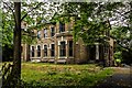
Oxford Place
Old house on Oxford Place.
Image: © Peter McDermott
Taken: 29 May 2017
0.08 miles
5
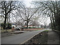
Lower Park Road, Victoria Park, Manchester
Many of the large houses here are used by the Xaverian College.
Image: © Tricia Neal
Taken: 30 Mar 2014
0.09 miles
6
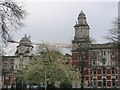
Central Manchester & Manchester Children's University Hospitals, MRI
Buildings that comprise part of the site commonly known as the Manchester Royal Infirmary (MRI) - Opposite site of Wilmslow Road to the Whitworth Art Gallery.
Image: © Paul Ashwin
Taken: 16 Apr 2005
0.10 miles
7
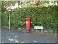
Victorian Postbox (M14 172D)
VR Postbox (M14 172D) on Conynham Road.
Image: © Gerald England
Taken: 1 Sep 2022
0.11 miles
8
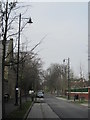
Upper Park Road, Victoria Park, Manchester
The red brick wall on the right surrounds the Manchester Central Mosque and Islamic Cultural Centre.
Image: © Tricia Neal
Taken: 30 Mar 2014
0.11 miles
9
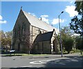
St Chrysostom's Church
The Grade II listed https://historicengland.org.uk/listing/the-list/list-entry/1197763?section=official-list-entry Church of St Chrysostom dates from 1874.
The church's patron saint is Saint John Chrysostom. It is one of three working churches dedicated in honour of St John Chrysostom in the Church of England; the others are in Liverpool Image and South London Image
Church website: http://stchrysostoms.weebly.com/
Image: © Gerald England
Taken: 1 Sep 2022
0.11 miles
10
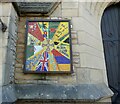
Welcoming Mosaic at St Chrysostom's Church (left)
Two new mosaics at the main door of St Chrysostom's Church Image were erected in 2014.
Children from Year 6 (this year's leavers) from both St Chrysostom's and St John's schools helped with the design and the construction of the mosaics, guided by Angie, a local mosaicist and community artist. Those helping were of different world faiths – it was an inter faith effort. https://stchrysostoms.wordpress.com/2014/07/11/welcoming-mosaics/
The mosaic, on the left hand side of the doors, has a cross in the middle and Welcome in several world languages – languages of people of our community. Clockwise from top: English, Japanese, Arabic, Ibo, Spanish, Urdu. In the mosaic are flags of nations represented in our varied local area. Bangladesh, Jamaica, Armenia, United Kingdom, Pakistan, China.
Image: © Gerald England
Taken: 1 Sep 2022
0.11 miles