IMAGES TAKEN NEAR TO
Daisy Bank Road, MANCHESTER, M14 5QL

Introduction

This page details the photographs taken nearby to Daisy Bank Road, M14 5QL by members of the Geograph project.

The Geograph project started in 2005 with the aim of publishing, organising and preserving representative images for every square kilometre of Great Britain, Ireland and the Isle of Man.

There are currently over 7.5m images from over14,400 individuals and you can help contribute to the project by visiting https://www.geograph.org.uk

Image Map


Images are licensed for reuse under creativecommons.org/licenses/by-sa/2.0
Notes
  • Clicking on the map will re-center to the selected point.
  • The higher the marker number, the further away the image location is from the centre of the postcode.

Image Listing (76 Images Found)

Images are licensed for reuse under creativecommons.org/licenses/by-sa/2.0
  • ...
Image
Details
Distance
1
Triangular Junction
The builders of Hathersage Road and Richmond Grove created an elegant triangular junction, complete with gracefully curved terraced housing on at least two sides.
Image: © Peter Whatley Taken: 21 Jan 2009
0.13 miles
2
New house
Image: © Alex McGregor Taken: 2 Jun 2011
0.13 miles
3
Addison Terrace, Daisy Bank Road, Manchester
A Tudor-Gothic terrace of twelve houses, arranged in six pairs, built c1850. Grade II listed.
Image: © Stephen Richards Taken: 17 Aug 2016
0.13 miles
4
Rebuilt property and shop
Image: © Alex McGregor Taken: 2 Jun 2011
0.14 miles
5
Portland Crescent
Image: © Colin Pyle Taken: 21 May 2010
0.16 miles
6
Milverton Road, Manchester
A typical Victorian street near Victoria Park probably accommodating a fair few students.
Image: © Stephen Richards Taken: 12 Jun 2016
0.16 miles
7
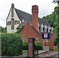
Former church, Daisy Bank Road, Manchester
Edgar Wood's church for the Christian Scientists, built in 1903-04, was "one of the most original buildings of that time in England or indeed anywhere". In plan it is Y-shaped or a butterfly plan. Grade I listed. After closing as a church in 1971 it housed the Edgar Wood Centre. That closed in 2003 and it has now resumed operation as a different flavour of church.
Image: © Stephen Richards Taken: 12 Jun 2016
0.17 miles
8
Hathersage Road
Image: © Peter McDermott Taken: 10 Oct 2021
0.17 miles
9
Hathersage Road and the Victoria Baths
When built, this was considered a rather superior area in which to live. The Victoria Baths on the right added a touch of splendour. After many years of steady decline, the area is being rejuvenated and the Baths are the subject of a multi-million pound renovation.
Image: © Peter Whatley Taken: 21 Jan 2009
0.17 miles
10
St Joseph's Catholic Church
Image: © Graham Hogg Taken: 9 May 2012
0.17 miles
  • ...