1
Parade of shops in Laindon Road Longsight
Image: © Rod Allday
Taken: 12 Apr 2014
0.11 miles
2
Milverton Road, Manchester
A typical Victorian street near Victoria Park probably accommodating a fair few students.
Image: © Stephen Richards
Taken: 12 Jun 2016
0.12 miles
3
Green space off Anson Road
Between Kinross Road and Upper Kent Road.
Image: © Gerald England
Taken: 26 Feb 2022
0.18 miles
4
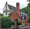
Victoria Park Christian Fellowship
An independent, evangelical church in Daisy Bank Road.
Image: © Rod Allday
Taken: 12 Apr 2014
0.18 miles
5
17 Anson Road, Manchester
Built as a private house, Milverton Lodge, in the mid/late C19th with copious Gothic tracery. Grade II listed.
At the time it was the Rampant Lion Hotel, which has since shut.
Image: © Stephen Richards
Taken: 12 Jun 2016
0.18 miles
6
Anson Road
The A34 towards Manchester City Centre.
Image: © Gerald England
Taken: 2 Aug 2010
0.18 miles
7
Rampant Lion
The Rampant Lion restaurant and bar on Anson Road.
Image: © David Dixon
Taken: 28 Sep 2011
0.19 miles
8
Addison Terrace, Daisy Bank Road, Manchester
A Tudor-Gothic terrace of twelve houses, arranged in six pairs, built c1850. Grade II listed.
Image: © Stephen Richards
Taken: 17 Aug 2016
0.20 miles
9
Junction of Anson Road and Denison Road, Rusholme
Image: © Eirian Evans
Taken: 18 Jan 2008
0.21 miles
10
Former church, Daisy Bank Road, Manchester
Edgar Wood's church for the Christian Scientists, built in 1903-04, was "one of the most original buildings of that time in England or indeed anywhere". In plan it is Y-shaped or a butterfly plan. Grade I listed.
After closing as a church in 1971 it housed the Edgar Wood Centre. That closed in 2003 and it has now resumed operation as a different flavour of church.
Image: © Stephen Richards
Taken: 12 Jun 2016
0.21 miles


