IMAGES TAKEN NEAR TO
Langdale Road, MANCHESTER, M14 5PN
Introduction
This page details the photographs taken nearby to Langdale Road, M14 5PN by members of the Geograph project.
The Geograph project started in 2005 with the aim of publishing, organising and preserving representative images for every square kilometre of Great Britain, Ireland and the Isle of Man.

There are currently over 7.5m images from over14,400 individuals and you can help contribute to the project by visiting https://www.geograph.org.uk
Image Map
Images are licensed for reuse under creativecommons.org/licenses/by-sa/2.0
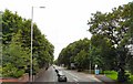
Notes
- Clicking on the map will re-center to the selected point.
- The higher the marker number, the further away the image location is from the centre of the postcode.
Image Listing (91 Images Found)
Images are licensed for reuse under creativecommons.org/licenses/by-sa/2.0
Image
Details
Distance
1
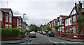
Milverton Road, Manchester
A typical Victorian street near Victoria Park probably accommodating a fair few students.
Image: © Stephen Richards
Taken: 12 Jun 2016
0.06 miles
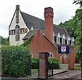
2
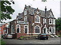
17 Anson Road, Manchester
Built as a private house, Milverton Lodge, in the mid/late C19th with copious Gothic tracery. Grade II listed.
At the time it was the Rampant Lion Hotel, which has since shut.
Image: © Stephen Richards
Taken: 12 Jun 2016
0.08 miles
3
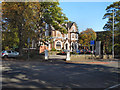
Rampant Lion
The Rampant Lion restaurant and bar on Anson Road.
Image: © David Dixon
Taken: 28 Sep 2011
0.08 miles
4
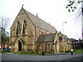
Former church, Daisy Bank Road, Manchester
Edgar Wood's church for the Christian Scientists, built in 1903-04, was "one of the most original buildings of that time in England or indeed anywhere". In plan it is Y-shaped or a butterfly plan. Grade I listed.
After closing as a church in 1971 it housed the Edgar Wood Centre. That closed in 2003 and it has now resumed operation as a different flavour of church.
Image: © Stephen Richards
Taken: 12 Jun 2016
0.12 miles
5
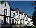
Addison Terrace, Daisy Bank Road, Manchester
A Tudor-Gothic terrace of twelve houses, arranged in six pairs, built c1850. Grade II listed.
Image: © Stephen Richards
Taken: 17 Aug 2016
0.12 miles
6
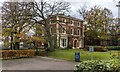
University of Manchester
Dalton Ellis Hall at the University of Manchester.
Image: © Peter McDermott
Taken: 22 Nov 2015
0.13 miles
7
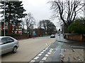
Junction of Anson Road and Denison Road, Rusholme
Image: © Eirian Evans
Taken: 18 Jan 2008
0.14 miles
8
Anson Road
The A34 towards Manchester City Centre.
Image: © Gerald England
Taken: 2 Aug 2010
0.17 miles
9
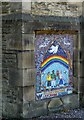
Mosaic at St Chrysostom's Church (1)
One of two mosaics erected on the outside of St Chrysostom's Church Image in 2012. They were designed by the Year 6 children from the primary school.
This one shows different children holding a prayer ribbon, as used on the church outside prayer tree. The children are united, it tells us, in aspiration, hope and prayer. Above the children is a rainbow, a sign of variety and inclusion. Different colours make up one rainbow. The dove above the children is the dove which signified the end of the flood and God's peace, from the story of Noah. This dove is a logo of church and of St Chrysostom's School. Above the rainbow are more doves, copies of those found on a stained glass window in the Anson Chapel in church. The crown in the mosaic is a reminder of the Queen's Jubilee year, and the words are words of qualities that unite us, chosen by the children: love, laughter, growing together. https://stchrysostoms.wordpress.com/2012/07/21/our-new-mosaics/
Image: © Gerald England
Taken: 1 Sep 2022
0.17 miles