IMAGES TAKEN NEAR TO
Oxford Place, MANCHESTER, M14 5GS
Introduction
This page details the photographs taken nearby to Oxford Place, M14 5GS by members of the Geograph project.
The Geograph project started in 2005 with the aim of publishing, organising and preserving representative images for every square kilometre of Great Britain, Ireland and the Isle of Man.

There are currently over 7.5m images from over14,400 individuals and you can help contribute to the project by visiting https://www.geograph.org.uk
Image Map
Images are licensed for reuse under creativecommons.org/licenses/by-sa/2.0
Notes
- Clicking on the map will re-center to the selected point.
- The higher the marker number, the further away the image location is from the centre of the postcode.
Image Listing (89 Images Found)
Images are licensed for reuse under creativecommons.org/licenses/by-sa/2.0
Image
Details
Distance
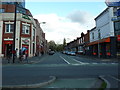
1
Oxford Place
Old house on Oxford Place.
Image: © Peter McDermott
Taken: 29 May 2017
0.02 miles
2
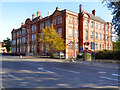
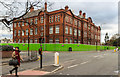
Manchester Metropolitan University, Elizabeth Gaskell Building
The University's Elizabeth Gaskell campus on Hathersage Road.
Opened in 1912 (Image]) as "The Manchester College of Domestic Science", the building later became "The Elizabeth Gaskell College of Education" in the early 1960s. In 1982, as a cost cutting measure, the college was absorbed by Manchester Polytechinc which later became the Manchester Metropolitan University. (http://yourarchives.nationalarchives.gov.uk/index.php?title=Elizabeth_Gaskell_College_of_Education_Manchester - Your Archives)
Image: © David Dixon
Taken: 28 Sep 2011
0.09 miles
3

Elizabeth Gaskell Building (memorial stone)
The memorial stone set in the wall of Image] when it opened as "the Manchester College of Domestic Science" in 1912.
Image: © David Dixon
Taken: 28 Sep 2011
0.10 miles
5
Manchester Metropolitan University
The Elizabeth Gaskell Building at Manchester Metropolitan University.
Image: © Peter McDermott
Taken: 22 Nov 2015
0.11 miles
6
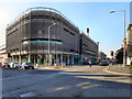
The Hathersage Centre
Large, modern, NHS health centre on Upper Brook Street in Manchester.
Image: © David Dixon
Taken: 28 Sep 2011
0.12 miles
7
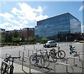
Central Manchester University NHS Foundation Trust Campus
The space in the foreground is outside the entrance to Manchester Children's Hospital.
The Citylabs 2.0 building in the background was completed in 2020. Occupied in full by life sciences firm Qiagen, the Citylabs campus within the healthcare-focused Oxford Road corridor is being developed by Manchester Science Partnerships and Manchester University NHS Foundation Trust as a hub for companies working in areas such as medtech, digital health, genomics, precision medicine, data analysis and diagnostics. https://www.placenorthwest.co.uk/citylabs-2-0-nears-completion/
Image: © Gerald England
Taken: 20 Aug 2022
0.12 miles
8
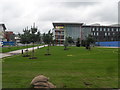
The New Manchester Children's Hospital
Image: © Anthony Parkes
Taken: 30 Jul 2010
0.12 miles
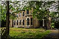
9
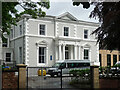
3 Lower Park Road, Manchester
A rich villa built around 1840 with an ornate Ionic portico. Grade II listed.
Now part of Xaverian Sixth Form College.
Image: © Stephen Richards
Taken: 12 Jun 2016
0.13 miles