IMAGES TAKEN NEAR TO
Conyngham Road, MANCHESTER, M14 5DX
Introduction
This page details the photographs taken nearby to Conyngham Road, M14 5DX by members of the Geograph project.
The Geograph project started in 2005 with the aim of publishing, organising and preserving representative images for every square kilometre of Great Britain, Ireland and the Isle of Man.

There are currently over 7.5m images from over14,400 individuals and you can help contribute to the project by visiting https://www.geograph.org.uk
Image Map
Images are licensed for reuse under creativecommons.org/licenses/by-sa/2.0
Notes
- Clicking on the map will re-center to the selected point.
- The higher the marker number, the further away the image location is from the centre of the postcode.
Image Listing (46 Images Found)
Images are licensed for reuse under creativecommons.org/licenses/by-sa/2.0
Image
Details
Distance
1
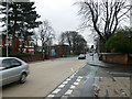
Junction of Anson Road and Denison Road, Rusholme
Image: © Eirian Evans
Taken: 18 Jan 2008
0.03 miles
2
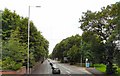
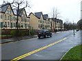
Anson Road
The A34 towards Manchester City Centre.
Image: © Gerald England
Taken: 2 Aug 2010
0.07 miles
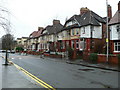
3
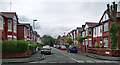
Milverton Road, Manchester
A typical Victorian street near Victoria Park probably accommodating a fair few students.
Image: © Stephen Richards
Taken: 12 Jun 2016
0.11 miles
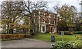
4
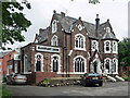
17 Anson Road, Manchester
Built as a private house, Milverton Lodge, in the mid/late C19th with copious Gothic tracery. Grade II listed.
At the time it was the Rampant Lion Hotel, which has since shut.
Image: © Stephen Richards
Taken: 12 Jun 2016
0.12 miles
5
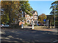
Rampant Lion
The Rampant Lion restaurant and bar on Anson Road.
Image: © David Dixon
Taken: 28 Sep 2011
0.12 miles
6
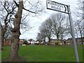
Green space off Anson Road
Between Kinross Road and Upper Kent Road.
Image: © Gerald England
Taken: 26 Feb 2022
0.12 miles
7
University of Manchester
Dalton Ellis Hall at the University of Manchester.
Image: © Peter McDermott
Taken: 22 Nov 2015
0.13 miles
8
Denison Road housing
Original 1930's houses on Denison Road in Rusholme
Image: © Eirian Evans
Taken: 18 Jan 2008
0.14 miles
9
Denison Road housing
The south side of Denison Road in Rusholme has seen the demolition of its 1930s houses and blocks of flats have sprung up in their place.
Image: © Eirian Evans
Taken: 18 Jan 2008
0.14 miles
10
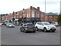
Anson Parade
The parade of shops on the corner of Dickenson Road (A6010) and Anson Road (A34) date from 1925 Image
Image: © Gerald England
Taken: 26 Feb 2022
0.14 miles