IMAGES TAKEN NEAR TO
Bowes Street, MANCHESTER, M14 4TD
Introduction
This page details the photographs taken nearby to Bowes Street, M14 4TD by members of the Geograph project.
The Geograph project started in 2005 with the aim of publishing, organising and preserving representative images for every square kilometre of Great Britain, Ireland and the Isle of Man.

There are currently over 7.5m images from over14,400 individuals and you can help contribute to the project by visiting https://www.geograph.org.uk
Image Map
Images are licensed for reuse under creativecommons.org/licenses/by-sa/2.0
Notes
- Clicking on the map will re-center to the selected point.
- The higher the marker number, the further away the image location is from the centre of the postcode.
Image Listing (44 Images Found)
Images are licensed for reuse under creativecommons.org/licenses/by-sa/2.0
Image
Details
Distance
1
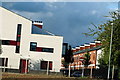
Infusion Homes and Cowesby Street in Moss Side, Manchester
Infusion homes is a housing development in Moss Side, Manchester. Constructed in 2011 it consists of a mixture of new build and renovated houses.
Image: © Stephen Taylor
Taken: 7 Sep 2013
0.02 miles
2
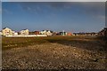
Moss Side
The site of Bowes Street Bus Depot and Bishop Bilsborrow School in Moss Side.
Image: © Peter McDermott
Taken: 15 Feb 2015
0.04 miles
3
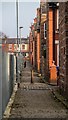
Moss Side
Back lane in Moss Side. For a view in the reverse direction see Image
Image: © Peter McDermott
Taken: 15 Feb 2015
0.06 miles
4
Infusion Homes on Bowes Street in Moss Side, Manchester
Infusion Homes is a housing development in Moss Side, Manchester, constructed in 2011 and consisting of new build and renovated houses. View from Alexandra Park, Whalley Range.
Image: © Stephen Taylor
Taken: 14 Apr 2012
0.07 miles
5
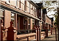
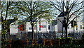
Elmswood Avenue in Moss Side, Manchester
Image: © Stephen Taylor
Taken: 24 Oct 2010
0.07 miles
6
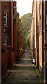
Backalley in Moss Side, Manchester
Backalley between residential streets and old tram station, now a bus depot, in Moss Side, Manchester. The bus depot is due to be demolished in 2011.
Image: © Stephen Taylor
Taken: 9 Oct 2010
0.07 miles
7
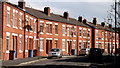
Edith Avenue in Moss Side
Edith Avenue in Moss Side, Manchester
Image: © Stephen Taylor
Taken: 14 Mar 2011
0.08 miles
8
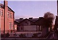
School Yard, Bishop Bilsborrow Memorial School, Princess Road, Moss Side
The low building at the rear of the school yard was a prefabricated building, or "prefab" and provided accommodation for two classes in 1950's. The passageway alongside the school leads in the direction of the Maine Road football ground. The Maine Road football ground no longer exists as the ground has moved to the Etihad Stadium. The school was demolished in 2011. Also see Image] Image] Image] Image]
Image: © Tom Jolliffe
Taken: Unknown
0.10 miles
9
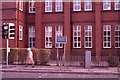
Bishop Bilsborrow Memorial School, Princess Road, Moss Side
A closer view of the classrooms in the Bishop Bilsborrow Memorial School. This school opened in 1909. Please see description of this school in other posted images. School design of this era ensured that the bottom of the windows was relatively high from floor. While this may have been related to safety considerations, it also prevented children from looking out of the windows, except in an upwards direction. The school was demolished in 2011. Also see Image] Image] Image] Image]
Image: © Tom Jolliffe
Taken: Unknown
0.11 miles
10
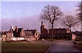
Alexandra Park, Moss Side, Manchester
From this part of Alexandra Park, there are old park buildings within the park on the Left. The white clock tower at the far left is part of the old bus station. Beyond the barn like park buildings on the right of the photo, the large brick building of the Bishop Bilsborrow Memorial School is visible. This school was demolished in 2011. The park entrance is at the extreme right of the photograph. Also see Image] Image] Image] Image]
Image: © Tom Jolliffe
Taken: Unknown
0.11 miles