IMAGES TAKEN NEAR TO
Bloom Street, MANCHESTER, M1 3HH
Introduction
This page details the photographs taken nearby to Bloom Street, M1 3HH by members of the Geograph project.
The Geograph project started in 2005 with the aim of publishing, organising and preserving representative images for every square kilometre of Great Britain, Ireland and the Isle of Man.

There are currently over 7.5m images from over14,400 individuals and you can help contribute to the project by visiting https://www.geograph.org.uk
Image Map
Images are licensed for reuse under creativecommons.org/licenses/by-sa/2.0
Notes
- Clicking on the map will re-center to the selected point.
- The higher the marker number, the further away the image location is from the centre of the postcode.
Image Listing (2475 Images Found)
Images are licensed for reuse under creativecommons.org/licenses/by-sa/2.0
Image
Details
Distance
1
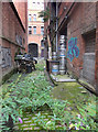
Alley between Richmond Street and Bloom Street, Manchester
Image: © habiloid
Taken: 7 Sep 2019
0.01 miles
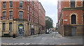
2
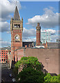
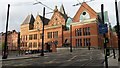
View from Bloom Street, Manchester (2)
Looking north-east along Bloom Street.
The Crown Court looms largest: Image
Further away, whiter and more modern is: Image
Image: © Stephen Richards
Taken: 16 May 2012
0.01 miles
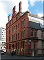
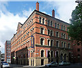
3
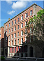
11 Bloom Street, Manchester
Substantial but very much a plain Jane among Manchester's former warehouses. By Pennington & Bridgen, 1889. Grade II listed.
Image: © Stephen Richards
Taken: 16 May 2012
0.01 miles
4
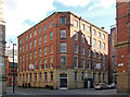
10 Minshull Street, Manchester
Aka Mindel House. A fairly modest mid-C19th warehouse, the modesty being gauged by the amount of ornament. This has a stone ground floor and quoins but little else. It is nevertheless easy on the eye. Grade II listed.
Image: © Stephen Richards
Taken: 16 May 2012
0.01 miles
5
Bloom Street, Manchester
View long Bloom Street from its corner with Minshull Street.
Image: © habiloid
Taken: 7 Sep 2019
0.02 miles
6
12 Minshull Street, Manchester
The front gives an appearance of being paper thin, as if applied later. The brick is exposed round the corner. Quite decorative with a jolly roofline, not run of the mill.
Now the Manchester base of the National Probation Service.
Image: © Stephen Richards
Taken: 16 May 2012
0.02 miles
7
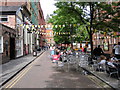
Canal Street
Manchesters "Gay Village". Looking north-east from Chorlton St. The street runs alongside the Rochdale Canal.
Image: © David Newton
Taken: 12 Jun 2009
0.02 miles
8
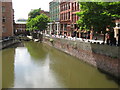
Canal Street, Manchester
Looking down the Rochdale Canal towards Lock 86 (Chorlton Street Lock).
Image: © Richard Rogerson
Taken: 15 Jul 2009
0.02 miles
9
Manchester morning sunlight
Note the tramlines and tram warning sign for pedestrians.
Image: © David Martin
Taken: 22 Oct 2014
0.02 miles
10
8 Minshull Street, Manchester
Mid/late-C19th shipping warehouse. The usual combination of red brick with stone window dressings, varying on each floor. In this case, the facades also differ as the main front (on Bloom Street) has paired windows (as well as a ridiculously under-scaled pediment) unlike the short front to Minshull Street. Grade II listed.
It is currently a nightclub, Essential.
Image: © Stephen Richards
Taken: 24 Jul 2011
0.02 miles