IMAGES TAKEN NEAR TO
Cobourg Street, MANCHESTER, M1 3GY
Introduction
This page details the photographs taken nearby to Cobourg Street, M1 3GY by members of the Geograph project.
The Geograph project started in 2005 with the aim of publishing, organising and preserving representative images for every square kilometre of Great Britain, Ireland and the Isle of Man.

There are currently over 7.5m images from over14,400 individuals and you can help contribute to the project by visiting https://www.geograph.org.uk
Image Map
Images are licensed for reuse under creativecommons.org/licenses/by-sa/2.0
Notes
- Clicking on the map will re-center to the selected point.
- The higher the marker number, the further away the image location is from the centre of the postcode.
Image Listing (1699 Images Found)
Images are licensed for reuse under creativecommons.org/licenses/by-sa/2.0
Image
Details
Distance
2
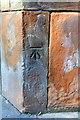
Benchmark on #11 Whitworth Street
Ordnance Survey cut mark benchmark described on the Bench Mark Database at http://www.bench-marks.org.uk/bm60619
Image: © Roger Templeman
Taken: 22 Sep 2014
0.02 miles
3
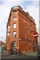
Fire Station
The old fire station building in Manchester.
Image: © Peter McDermott
Taken: 5 Apr 2015
0.02 miles
4
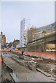
Laying tram tracks
Laying the tracks for the Metrolink tram outside Piccadilly station
Image: © Stephen Craven
Taken: 19 Mar 1991
0.02 miles
5
#11 Whitworth Street at Minshull Street South/Fairfield Street junction
There is an OS benchmark Image just above pavement level below the Minshull Street South name sign
Image: © Roger Templeman
Taken: 22 Sep 2014
0.02 miles
6
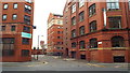
Back Acton Street, Manchester
Back Acton Street lies close to Manchester's Piccadilly railway station and the canal. Buildings here are former warehouses.
Image: © Malc McDonald
Taken: 25 Apr 2014
0.03 miles

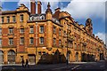
8

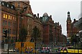
Former police station: arms of Manchester on Minshull Street South corner
Image: © Christopher Hilton
Taken: 24 Oct 2009
0.03 miles

10
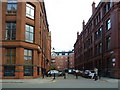
Looking south off Whitworth Street
The buildings on the left of the photograph form part of Manchester
University, as the purple sign high on the further one indicates; they
used to form part of the University of Manchester Institute of Science
and Technology (UMIST), as it then was.
Image: © Christopher Hilton
Taken: 24 Oct 2009
0.03 miles