IMAGES TAKEN NEAR TO
Piccadilly, MANCHESTER, M1 3AN
Introduction
This page details the photographs taken nearby to Piccadilly, M1 3AN by members of the Geograph project.
The Geograph project started in 2005 with the aim of publishing, organising and preserving representative images for every square kilometre of Great Britain, Ireland and the Isle of Man.

There are currently over 7.5m images from over14,400 individuals and you can help contribute to the project by visiting https://www.geograph.org.uk
Image Map (Loading...)


Getting Data...Please wait
Leaflet Map data © OpenStreetMap
Images are licensed for reuse under creativecommons.org/licenses/by-sa/2.0
Notes
- Clicking on the map will re-center to the selected point.
- The higher the marker number, the further away the image location is from the centre of the postcode.
Image Listing (2607 Images Found)
Images are licensed for reuse under creativecommons.org/licenses/by-sa/2.0
Image
Details
Distance
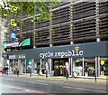
1
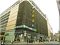
Cycling invasion by stealth
Cycle Republic, a rapidly expanding chain (no pun intended), has occupied part of the enemy territory of a NCP car park on Manchester's Piccadilly.
Image: © Stephen Craven
Taken: 11 Mar 2017
0.01 miles
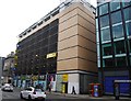
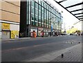
3
Pure Electric shop for sale
The Pure Electric shop at the top of London Road Image which had taken over the former Halford's owned "cycle republic" Image store is now itself for sale.
Image: © Gerald England
Taken: 3 Apr 2023
0.01 miles
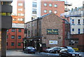
4
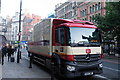
Palmer and Harvey Lorry
Palmer and Harvey are distributors of food to convenience stores.
This particular vehicle is a Mercedes-Benz Antos
Image: © Bob Harvey
Taken: 27 Oct 2017
0.01 miles
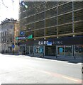
5
cycle republic
Cycle Republic described themselves http://web.archive.org/web/20200309095717/https://www.cyclescheme.co.uk/retailer/cycle-republic-manchester as "a one stop bike shop catering for cyclists in the busiest commuter areas."
Update (August 2020): Now replaced by Pure Electric Image
Image: © Gerald England
Taken: 4 Sep 2019
0.01 miles
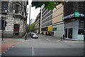
7
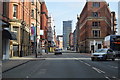
A6 at Piccadilly
The A6 heads into the city centre via London Road and Piccadilly, but loses its number and vanishes. It would have gone straight down Piccadilly and Market Street to meet Deansgate, and then across the River Irwell into Salford, and up Chapel Street, where the number reappears. Market Street has been pedestrianised for years, so the A6 has long ceased to be a through route. https://www.sabre-roads.org.uk/wiki/index.php?title=A6/Hazel_Grove_-_Manchester
There are two bus stops outside Tesco Express. These are only used by one of the free around the city shuttle buses and replacement buses only required when Metrolink trams through Piccadilly Gardens are out of operation for some reason.
Image: © Gerald England
Taken: 11 Oct 2020
0.02 miles
10
City Centre Living
Apartments above Circus Street in central Manchester.
Image: © Keith Williamson
Taken: 24 Aug 2007
0.02 miles