IMAGES TAKEN NEAR TO
Bramwell Drive, MANCHESTER, M13 9YB
Introduction
This page details the photographs taken nearby to Bramwell Drive, M13 9YB by members of the Geograph project.
The Geograph project started in 2005 with the aim of publishing, organising and preserving representative images for every square kilometre of Great Britain, Ireland and the Isle of Man.

There are currently over 7.5m images from over14,400 individuals and you can help contribute to the project by visiting https://www.geograph.org.uk
Image Map
Images are licensed for reuse under creativecommons.org/licenses/by-sa/2.0
Notes
- Clicking on the map will re-center to the selected point.
- The higher the marker number, the further away the image location is from the centre of the postcode.
Image Listing (79 Images Found)
Images are licensed for reuse under creativecommons.org/licenses/by-sa/2.0
Image
Details
Distance
1
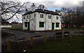
The Cleveland
The now closed Cleveland public house off Stockport Road, on the corner of Wilson Street and Thompson Street in Ardwick.
Image: © Peter McDermott
Taken: 25 Mar 2018
0.08 miles
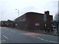
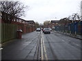
2

Wilson Street
Wilson Street in Brunswick.
Image: © Peter McDermott
Taken: 17 Apr 2017
0.09 miles
3
Stockport Road, Ardwick
The A6 out of Manchester.
Image: © Gerald England
Taken: 11 Sep 2009
0.09 miles
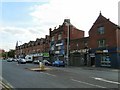
4
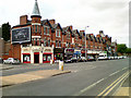
Stockport Road
Row of shops along Stockport Road (A6)
Image: © David Dixon
Taken: 19 May 2010
0.09 miles
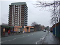
8
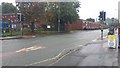
Pelican crossing, Brunswick Street
The building in the background (far right) is the University of Manchester Chemistry Building.
Image: © Bradley Michael
Taken: 21 Sep 2015
0.11 miles