IMAGES TAKEN NEAR TO
Wadeson Road, MANCHESTER, M13 9TU
Introduction
This page details the photographs taken nearby to Wadeson Road, M13 9TU by members of the Geograph project.
The Geograph project started in 2005 with the aim of publishing, organising and preserving representative images for every square kilometre of Great Britain, Ireland and the Isle of Man.

There are currently over 7.5m images from over14,400 individuals and you can help contribute to the project by visiting https://www.geograph.org.uk
Image Map
Images are licensed for reuse under creativecommons.org/licenses/by-sa/2.0
Notes
- Clicking on the map will re-center to the selected point.
- The higher the marker number, the further away the image location is from the centre of the postcode.
Image Listing (121 Images Found)
Images are licensed for reuse under creativecommons.org/licenses/by-sa/2.0
Image
Details
Distance
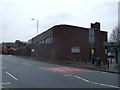
2
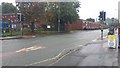
Pelican crossing, Brunswick Street
The building in the background (far right) is the University of Manchester Chemistry Building.
Image: © Bradley Michael
Taken: 21 Sep 2015
0.05 miles
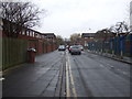
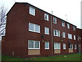
4
Tyldesley Street
Tyldesley Street in Moss Side with Mosscare Housing development
Image: © Stephen Taylor
Taken: 13 Mar 2011
0.06 miles
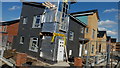
8
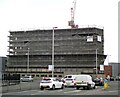
Building work at Ancoats
More apartments under construction.
Image: © Gerald England
Taken: 21 Apr 2021
0.08 miles
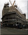
9
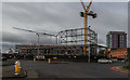
Polygon Street Development
The new Polygon Street development.
Image: © Peter McDermott
Taken: 17 Apr 2017
0.08 miles