IMAGES TAKEN NEAR TO
Kincardine Road, MANCHESTER, M13 9SY
Introduction
This page details the photographs taken nearby to Kincardine Road, M13 9SY by members of the Geograph project.
The Geograph project started in 2005 with the aim of publishing, organising and preserving representative images for every square kilometre of Great Britain, Ireland and the Isle of Man.

There are currently over 7.5m images from over14,400 individuals and you can help contribute to the project by visiting https://www.geograph.org.uk
Image Map
Images are licensed for reuse under creativecommons.org/licenses/by-sa/2.0
Notes
- Clicking on the map will re-center to the selected point.
- The higher the marker number, the further away the image location is from the centre of the postcode.
Image Listing (90 Images Found)
Images are licensed for reuse under creativecommons.org/licenses/by-sa/2.0
Image
Details
Distance
1

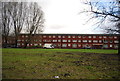
Brunswick parish church - interior
A modern building, at the time of the photo known as All Saints, Chorlton although later (as of 2016) it became known as Christ Church, Brunswick.
Image: © Stephen Craven
Taken: 28 Aug 1988
0.07 miles

4
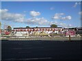
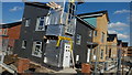
New Brunswick
Just off the A34 Upper Brook Street, Linden Homes are building new houses in an area that has become known as New Brunswick.
Image: © Gerald England
Taken: 15 Oct 2021
0.10 miles
6
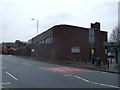
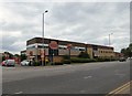
Chinese Restaurant and Supermarket
The Tai Pan Chinese restaurant and W H Lung Supermarket on Upper Brook Street.
Image: © Richard Sutcliffe
Taken: 16 Jun 2015
0.10 miles
7
Tai Pan
The Chinese restaurant on Upper Brook Street had a major refurbishment in 2014. http://www.taipanmanchester.co.uk/
Note: Photograph is for record purposes only. The photographer has no personal connection with the business depicted.
Image: © Gerald England
Taken: 7 Jul 2017
0.10 miles
8
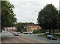
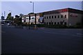
Upper Brook Street
The A34 into Manchester at its junction with Brunswick Street.
Image: © Gerald England
Taken: 2 Aug 2010
0.10 miles
9

Brunswick
Part of the redevelopment of Brunswick in Manchester.
Image: © Peter McDermott
Taken: 4 Jul 2015
0.10 miles
10
Tyldesley Street
Tyldesley Street in Moss Side with Mosscare Housing development
Image: © Stephen Taylor
Taken: 13 Mar 2011
0.10 miles