IMAGES TAKEN NEAR TO
Hutton Walk, MANCHESTER, M13 9SL
Introduction
This page details the photographs taken nearby to Hutton Walk, M13 9SL by members of the Geograph project.
The Geograph project started in 2005 with the aim of publishing, organising and preserving representative images for every square kilometre of Great Britain, Ireland and the Isle of Man.

There are currently over 7.5m images from over14,400 individuals and you can help contribute to the project by visiting https://www.geograph.org.uk
Image Map
Images are licensed for reuse under creativecommons.org/licenses/by-sa/2.0
Notes
- Clicking on the map will re-center to the selected point.
- The higher the marker number, the further away the image location is from the centre of the postcode.
Image Listing (96 Images Found)
Images are licensed for reuse under creativecommons.org/licenses/by-sa/2.0
Image
Details
Distance
1
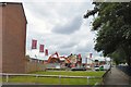
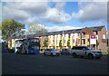
Demolition work on Plymouth View
Old houses on the Brunswick Estate are being demolished to make way for new houses which are being built by Linden Homes.
Image: © Gerald England
Taken: 7 Jul 2017
0.03 miles
3
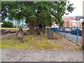
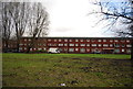
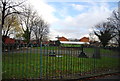
St Saviour's churchyard
St Saviour's on Plymouth Grove was consecrated in 1836. It was demolished in 1964. Gravestones remain around the churchyard and a simple cross stands on the site of the church. http://manchesterhistory.net/manchester/gone/stsaviours.html
Image: © Gerald England
Taken: 7 Jul 2017
0.05 miles
4
St Saviours Churchyard
St Saviours Church was built in 1840 and demolished in 1964, just the churchyard remains.
Image: © N Chadwick
Taken: 17 Dec 2011
0.06 miles
5
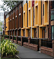
New Brunswick
Just off the A34 Upper Brook Street, Linden Homes are building new houses in an area that has become known as New Brunswick.
Image: © Gerald England
Taken: 15 Oct 2021
0.06 miles
7
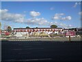
New Brunswick
Just off the A34 Upper Brook Street, Linden Homes are building new houses in an area that has become known as New Brunswick.
Image: © Gerald England
Taken: 15 Oct 2021
0.06 miles
8
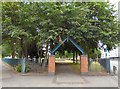
Entrance to St Saviour's
St Saviour's on Plymouth Grove was consecrated in 1836. It was demolished in 1964. Gravestones remain around the churchyard and a simple cross stands on the site of the church. http://manchesterhistory.net/manchester/gone/stsaviours.html
Image: © Gerald England
Taken: 7 Jul 2017
0.06 miles
9
St Saviours Churchyard
St Saviours Church was built in 1840 and demolished in 1964, just the churchyard remains.
Image: © N Chadwick
Taken: 17 Dec 2011
0.06 miles
10
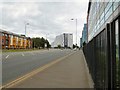
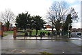
Upper Brook Street
The A34 out of Manchester. The new houses on the left are part of the Brunswick estate and were built by Linden Homes in 2015. Beyond the junction with Plymouth Grove (A5184) is Nick Everton House Image opened in 2007. The building on the right is part of the University of Manchester.
Image: © Gerald England
Taken: 7 Jul 2017
0.07 miles