IMAGES TAKEN NEAR TO
Wilmslow Road, MANCHESTER, M13 9PD
Introduction
This page details the photographs taken nearby to Wilmslow Road, M13 9PD by members of the Geograph project.
The Geograph project started in 2005 with the aim of publishing, organising and preserving representative images for every square kilometre of Great Britain, Ireland and the Isle of Man.

There are currently over 7.5m images from over14,400 individuals and you can help contribute to the project by visiting https://www.geograph.org.uk
Image Map
Images are licensed for reuse under creativecommons.org/licenses/by-sa/2.0
Notes
- Clicking on the map will re-center to the selected point.
- The higher the marker number, the further away the image location is from the centre of the postcode.
Image Listing (163 Images Found)
Images are licensed for reuse under creativecommons.org/licenses/by-sa/2.0
Image
Details
Distance
1
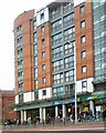
Wilmslow Park
Student accommodation at the corner of Oxford Road and Hathersage Road.
Image: © Gerald England
Taken: 18 Oct 2010
0.01 miles
2
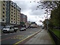
Bus stops on Oxford Road
Bus stops on the B5117 outside Whitworth Park.
Image: © Gerald England
Taken: 22 May 2021
0.03 miles
3
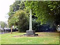
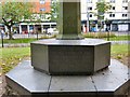
World War One Memorial in Whitworth Park
The memorial has been described as "A Forgotten University Memorial" http://www.ww1.manchester.ac.uk/a-forgotten-university-memorial-of-world-war-one/
It commemorates those who lost their lives in the 7th Battalion of the Manchester Regiment. The majority of this territorial battalion's recruits originated from the area of Manchester around the University and formed part of the renowned 42nd East Lancashire Division that distinguished itself in battles at Gallipoli, Egypt and on the Western front. The original war memorial that preceded the column situated in Whitworth Park was erected inside the Drill Hall and battalion headquarters which were located in the building now known as the McDougall Centre on Burlington Street. The building was sold in 1933 and this new memorial was unveiled by General Sir Reginald Wingate in September 1933.
Image: © Gerald England
Taken: 18 Aug 2018
0.04 miles
4
World War One Memorial in Whitworth Park
The memorial has been described as "A Forgotten University Memorial" http://www.ww1.manchester.ac.uk/a-forgotten-university-memorial-of-world-war-one/
It commemorates those who lost their lives in the 7th Battalion of the Manchester Regiment. The majority of this territorial battalion's recruits originated from the area of Manchester around the University and formed part of the renowned 42nd East Lancashire Division that distinguished itself in battles at Gallipoli, Egypt and on the Western front. The original war memorial that preceded the column situated in Whitworth Park was erected inside the Drill Hall and battalion headquarters which were located in the building now known as the McDougall Centre on Burlington Street. The building was sold in 1933 and this new memorial was unveiled by General Sir Reginald Wingate in September 1933.
Image: © Gerald England
Taken: 18 Aug 2018
0.04 miles
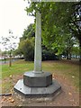
5
World War Two inscription on World War One Memorial
The inscription on one face of the Whitworth Park Memorial Image reads:
IN GLORIOUS MEMORY
OF ALL RANKS OF THE
7TH MANCHESTERS
WHO GAVE THEIR LIVES
FOR THEIR COUNTRY
1939 - 1945
Image: © Gerald England
Taken: 18 Aug 2018
0.04 miles
6
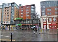
Rusholme, Ford Madox Brown
Wetherspoon's pub on the ground floor of a student accommodation block on Wilmslow Road. Single room, counter right, eating and drinking areas front, left and back; a pleasing subdued red and black decor. Some exposed brickwork and games machines. Six cask ales were on offer at my visit.
Image: © Mike Faherty
Taken: 7 Feb 2019
0.04 miles
7
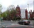
St Mary's Hospital
The Grade II listed building https://historicengland.org.uk/listing/the-list/list-entry/1246550 on the corner of Oxford Road (B5117) and Hathersage Road is by John Ely 1909.
Image: © Gerald England
Taken: 22 May 2021
0.05 miles
8
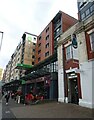
The Ford Maddox Brown public house
JD Wetherspoon on Wilmslow Road.
Image: © JThomas
Taken: 30 May 2024
0.05 miles
9
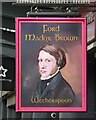
Sign for the Ford Maddox Brown public house
Image: © JThomas
Taken: 30 May 2024
0.05 miles
10
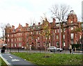
St Mary's Hospital, Oxford Road
The Grade II listed building by John Ely, 1909 https://historicengland.org.uk/listing/the-list/list-entry/1246550
has a long red brick and terracotta frontage divided into three by gabled bays and framed by octagonal-domed towers. St Mary's hospital had been established in 1790 by Charles White Image It moved here to the corner of Oxford Road and Hathersage Road in 1909. A modern building was added to it in 1971 only to be demolished in 2009/10 and replaced by an even newer building. http://manchesterhistory.net/manchester/tours/tour11/tour11.html It is now one part of the Central Manchester University Hospitals https://mft.nhs.uk/ which also includes the Manchester Royal Infirmary, the Royal Eye Hospital and the Royal Manchester Children's Hospital.
Image: © Gerald England
Taken: 11 Nov 2017
0.06 miles