IMAGES TAKEN NEAR TO
Astley Road, MANCHESTER, M13 9EH
Introduction
This page details the photographs taken nearby to Astley Road, M13 9EH by members of the Geograph project.
The Geograph project started in 2005 with the aim of publishing, organising and preserving representative images for every square kilometre of Great Britain, Ireland and the Isle of Man.

There are currently over 7.5m images from over14,400 individuals and you can help contribute to the project by visiting https://www.geograph.org.uk
Image Map
Images are licensed for reuse under creativecommons.org/licenses/by-sa/2.0
Notes
- Clicking on the map will re-center to the selected point.
- The higher the marker number, the further away the image location is from the centre of the postcode.
Image Listing (85 Images Found)
Images are licensed for reuse under creativecommons.org/licenses/by-sa/2.0
Image
Details
Distance
1
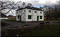
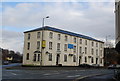
The Cleveland
The now closed Cleveland public house off Stockport Road, on the corner of Wilson Street and Thompson Street in Ardwick.
Image: © Peter McDermott
Taken: 25 Mar 2018
0.05 miles
2

Wilson Street
Wilson Street in Brunswick.
Image: © Peter McDermott
Taken: 17 Apr 2017
0.10 miles
3
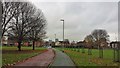
Cycle and pedestrian lane near Ardwick
An off road route for walkers and cyclists from the A5184 to Kincardine Road. The skyline of Manchester can be seen also.
Image: © Bradley Michael
Taken: 26 Nov 2015
0.10 miles
4
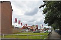
Demolition work on Plymouth View
Old houses on the Brunswick Estate are being demolished to make way for new houses which are being built by Linden Homes.
Image: © Gerald England
Taken: 7 Jul 2017
0.12 miles
5
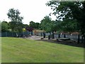
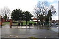
St Saviour's Churchyard
A grassy mound marks the site of the church, surrounded by the churchyard with gravestones.
Image: © David Martin
Taken: 7 Jul 2011
0.12 miles
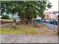
7
St Saviours Churchyard
St Saviours Church was built in 1840 and demolished in 1964, just the churchyard remains.
Image: © N Chadwick
Taken: 17 Dec 2011
0.14 miles
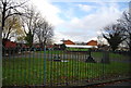
8
St Saviour's churchyard
St Saviour's on Plymouth Grove was consecrated in 1836. It was demolished in 1964. Gravestones remain around the churchyard and a simple cross stands on the site of the church. http://manchesterhistory.net/manchester/gone/stsaviours.html
Image: © Gerald England
Taken: 7 Jul 2017
0.14 miles
9
St Saviours Churchyard
St Saviours Church was built in 1840 and demolished in 1964, just the churchyard remains.
Image: © N Chadwick
Taken: 17 Dec 2011
0.14 miles
10
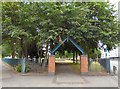
Entrance to St Saviour's
St Saviour's on Plymouth Grove was consecrated in 1836. It was demolished in 1964. Gravestones remain around the churchyard and a simple cross stands on the site of the church. http://manchesterhistory.net/manchester/gone/stsaviours.html
Image: © Gerald England
Taken: 7 Jul 2017
0.15 miles