IMAGES TAKEN NEAR TO
Tagore Close, MANCHESTER, M13 0YS
Introduction
This page details the photographs taken nearby to Tagore Close, M13 0YS by members of the Geograph project.
The Geograph project started in 2005 with the aim of publishing, organising and preserving representative images for every square kilometre of Great Britain, Ireland and the Isle of Man.

There are currently over 7.5m images from over14,400 individuals and you can help contribute to the project by visiting https://www.geograph.org.uk
Image Map
Images are licensed for reuse under creativecommons.org/licenses/by-sa/2.0
Notes
- Clicking on the map will re-center to the selected point.
- The higher the marker number, the further away the image location is from the centre of the postcode.
Image Listing (17 Images Found)
Images are licensed for reuse under creativecommons.org/licenses/by-sa/2.0
Image
Details
Distance
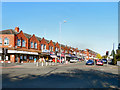
1
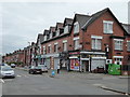
Parade of shops in Laindon Road Longsight
Image: © Rod Allday
Taken: 12 Apr 2014
0.07 miles
2
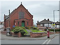
Victoria Park Christian Fellowship
An independent, evangelical church in Daisy Bank Road.
Image: © Rod Allday
Taken: 12 Apr 2014
0.17 miles
3
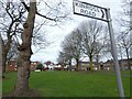
Green space off Anson Road
Between Kinross Road and Upper Kent Road.
Image: © Gerald England
Taken: 26 Feb 2022
0.18 miles
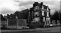
4
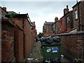
Inner city terraced houses - Rusholme
-
Image: © Jeff Thomas
Taken: 21 Apr 2005
0.19 miles
5
Dickenson Road
Shops at the busy crossroads of Dickenson Road (A6010) and Upper Brook Street/Birchfields Road (A34)
Image: © David Dixon
Taken: 28 Sep 2011
0.19 miles
6
Levenshulme
Property on the corner of Dickenson Road and Birch Lane in Levenshulme,
Image: © Peter McDermott
Taken: 17 Sep 2018
0.19 miles
7
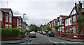
Milverton Road, Manchester
A typical Victorian street near Victoria Park probably accommodating a fair few students.
Image: © Stephen Richards
Taken: 12 Jun 2016
0.20 miles
8
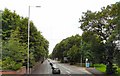
Anson Road
The A34 towards Manchester City Centre.
Image: © Gerald England
Taken: 2 Aug 2010
0.21 miles
9
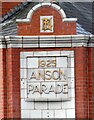
Anson Parade: architectural detail
Detail on the 1925 Anson Parade Image
Image: © Gerald England
Taken: 26 Feb 2022
0.22 miles
10
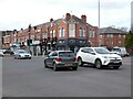
Anson Parade
The parade of shops on the corner of Dickenson Road (A6010) and Anson Road (A34) date from 1925 Image
Image: © Gerald England
Taken: 26 Feb 2022
0.22 miles