IMAGES TAKEN NEAR TO
Worthenbury Walk, MANCHESTER, M13 0XB
Introduction
This page details the photographs taken nearby to Worthenbury Walk, M13 0XB by members of the Geograph project.
The Geograph project started in 2005 with the aim of publishing, organising and preserving representative images for every square kilometre of Great Britain, Ireland and the Isle of Man.

There are currently over 7.5m images from over14,400 individuals and you can help contribute to the project by visiting https://www.geograph.org.uk
Image Map
Images are licensed for reuse under creativecommons.org/licenses/by-sa/2.0
Notes
- Clicking on the map will re-center to the selected point.
- The higher the marker number, the further away the image location is from the centre of the postcode.
Image Listing (29 Images Found)
Images are licensed for reuse under creativecommons.org/licenses/by-sa/2.0
Image
Details
Distance
1
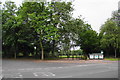
An entrance to Birchfields Park
This is from the junction of Birchfields Road and Birch Hall Lane.
Image: © Bill Boaden
Taken: 30 Jul 2010
0.12 miles
2
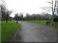
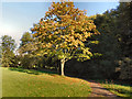
Birchfields Park
Birchfields Park was acquired by Manchester City Council in 1887 from local landowner Sir William Anson for the creation of a public park, and formally opened by Prince Albert in 1888.
The site's main landscape elements include a large area of amenity grassland enclosed by mature woodland, trees in grass, unimproved grassland, a wildflower meadow and a woodland garden.
Image: © Gerald England
Taken: 26 Feb 2022
0.12 miles
3
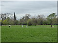
Playing cricket in Birchfields Park
A green space in the heavily built-up area in the south of Manchester.
Image: © Rod Allday
Taken: 12 Apr 2014
0.12 miles
4
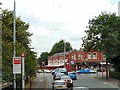
Rusholme Crossroads
Main road junction in Rusholme. Viewed from the top deck of a bus on Birchfields Road, the A34, which becomes Anson Road and then Upper Brook Street as it approaches Manchester City Centre. The road crossing is Dickenson Road, the Manchester Inner Ring Road A6010.
Image: © Gerald England
Taken: 2 Aug 2010
0.13 miles
5
Birchfields Park
Birchfields Park was acquired by Manchester City Council in 1887 from local landowner Sir William Anson for the creation of a public park, and formally opened by Prince Albert in 1888.
The site's main landscape elements include a large area of amenity grassland enclosed by mature woodland, trees in grass, unimproved grassland, a wildflower meadow and a woodland garden.
http://www.manchester.gov.uk/info/200073/parks_and_open_spaces/1476/birchfields_park/1 - Manchester City Council (about Birchfields Park)
Image: © David Dixon
Taken: 28 Sep 2011
0.14 miles
6
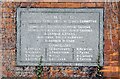
Birch Fields plaque
The stone plaque on the wall of Birchfields Park Lodge Image reads:
BIRCH FIELDS.
LAID OUT BY THE PARKS AND CEMETERIES COMMITTEE.
COUNCILLOR S. CHESTERS THOMPSON - CHAIRMAN.
COUNCILLOR C. KENWORTHY - DEPUTY - CHAIRMAN.
ALDERMAN A. EVANS.
ALDEMAN SIR J.J. HARWOOD.
ALDERMAN H. SHAW.
COUNCILLORS
R.AFFLECK | F.E.ESTCOURT | R.NEWTON
H.ALDRED | J.GRANTHAM | C.PAYNE
S.ASHCROFT | W.HOLT | N.C.SCHOU
A.C.COPELAND | C NEEDHAM | E.TATTON
OPENED 20TH OCTOBER 1888
Image: © Gerald England
Taken: 26 Feb 2022
0.14 miles
7
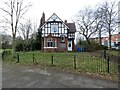
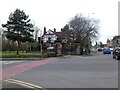
Birchfields Park Lodge
The lodge has an inscribed stone plaque on its wall Image
Image: © Gerald England
Taken: 26 Feb 2022
0.14 miles
8
Birchfields Park
Gatehouse at Birchfields Park in Rusholme.
Image: © Peter McDermott
Taken: 15 Feb 2015
0.14 miles
9
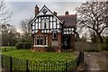
Junction of Birchfield Road and Dickenson Road
The A6010 Dickenson Road crosses the A34 by the entrance to Birchfields Park with its distinctive lodge Image
Image: © Gerald England
Taken: 26 Feb 2022
0.14 miles
10
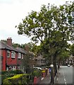
Birchfields Road
The A34 towards Manchester City Centre.
Image: © Gerald England
Taken: 2 Aug 2010
0.14 miles