IMAGES TAKEN NEAR TO
Elsdon Road, MANCHESTER, M13 0TW
Introduction
This page details the photographs taken nearby to Elsdon Road, M13 0TW by members of the Geograph project.
The Geograph project started in 2005 with the aim of publishing, organising and preserving representative images for every square kilometre of Great Britain, Ireland and the Isle of Man.

There are currently over 7.5m images from over14,400 individuals and you can help contribute to the project by visiting https://www.geograph.org.uk
Image Map
Images are licensed for reuse under creativecommons.org/licenses/by-sa/2.0
Notes
- Clicking on the map will re-center to the selected point.
- The higher the marker number, the further away the image location is from the centre of the postcode.
Image Listing (13 Images Found)
Images are licensed for reuse under creativecommons.org/licenses/by-sa/2.0
Image
Details
Distance
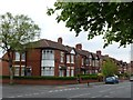
3
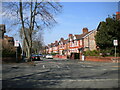
Reynell Road, Longsight
Off Hamilton Road.
Image: © Richard Vince
Taken: 17 Apr 2021
0.19 miles
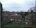
6
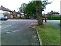
Fairview Avenue, Levenshulme
Off Slade Lane.
Image: © Richard Vince
Taken: 17 Apr 2021
0.20 miles
8
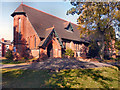
St Agnes' Church, Longsight
The Parish Church of St Agnes Birch with St John with St Cyprian, Longsight.
Image: © David Dixon
Taken: 28 Sep 2011
0.21 miles
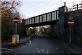
9
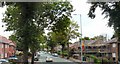
Birchfields Road
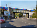
The A34 towards Manchester City Centre.
Image: © Gerald England
Taken: 2 Aug 2010
0.22 miles