IMAGES TAKEN NEAR TO
Tabley Grove, MANCHESTER, M13 0TJ
Introduction
This page details the photographs taken nearby to Tabley Grove, M13 0TJ by members of the Geograph project.
The Geograph project started in 2005 with the aim of publishing, organising and preserving representative images for every square kilometre of Great Britain, Ireland and the Isle of Man.

There are currently over 7.5m images from over14,400 individuals and you can help contribute to the project by visiting https://www.geograph.org.uk
Image Map
Images are licensed for reuse under creativecommons.org/licenses/by-sa/2.0
Notes
- Clicking on the map will re-center to the selected point.
- The higher the marker number, the further away the image location is from the centre of the postcode.
Image Listing (17 Images Found)
Images are licensed for reuse under creativecommons.org/licenses/by-sa/2.0
Image
Details
Distance
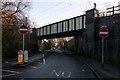
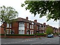
6
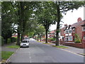
Birchfields Road
The A34 towards Manchester City Centre.
Image: © Gerald England
Taken: 2 Aug 2010
0.19 miles
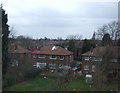
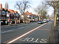
8
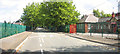
Lytham Road and Birchfields Primary School
Lytham Road looking East from Birchfields Road end with Birchfields Primary School on the right and MUTECH playing fields and pavilion on the left
Image: © Daniel P Short
Taken: 20 Aug 2005
0.20 miles
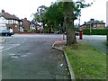
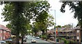
9
Old Hall Lane
Looking east towards the A34, Birchfields Road Junction.
Image: © Stephen Armstrong
Taken: 31 Jul 2011
0.21 miles