IMAGES TAKEN NEAR TO
Plymouth Grove, MANCHESTER, M13 0LX

Introduction

This page details the photographs taken nearby to Plymouth Grove, M13 0LX by members of the Geograph project.

The Geograph project started in 2005 with the aim of publishing, organising and preserving representative images for every square kilometre of Great Britain, Ireland and the Isle of Man.

There are currently over 7.5m images from over14,400 individuals and you can help contribute to the project by visiting https://www.geograph.org.uk

Image Map


Images are licensed for reuse under creativecommons.org/licenses/by-sa/2.0
Notes
  • Clicking on the map will re-center to the selected point.
  • The higher the marker number, the further away the image location is from the centre of the postcode.

Image Listing (38 Images Found)

Images are licensed for reuse under creativecommons.org/licenses/by-sa/2.0
  • ...
Image
Details
Distance
1
Victoria Park Christian Fellowship
An independent, evangelical church in Daisy Bank Road.
Image: © Rod Allday Taken: 12 Apr 2014
0.06 miles
2
422 Community Hub
422 Stockport Road was built in 1850 by the Mechanics Institution as a Public Library and Hall. It was the second free public library in England. For many years in the 20th century it was Longsight Youth Centre. Now led by a local church, Manchester Vineyard it has become a Community Hub.
Image: © Gerald England Taken: 26 Mar 2022
0.10 miles
3
422 Community Hub
422 Stockport Road was built in 1850 by the Mechanics Institution as a Public Library and Hall. It was the second free public library in England. For many years in the 20th century it was Longsight Youth Centre. Now led by a local church, Manchester Vineyard it has become a Community Hub.
Image: © Gerald England Taken: 26 Mar 2022
0.10 miles
4
Anyone going to nick those cars?
Illegally parked cars in profusion outside Longsight police station. I wonder who they belong to?
Image: © Peter Whatley Taken: 21 Jan 2009
0.10 miles
5
Stockport Road
The A6 towards Manchester. On the opposite side are a pair of 192s. The one in front is going to Stepping Hill Hospital. The one behind is terminating at Stockport College.
Image: © Gerald England Taken: 18 May 2023
0.11 miles
6
420-424 Stockport Road, Manchester
Nos. 420-422 was at various times a public hall and (when this photo was taken) Longsight Youth Centre (both engraved on the front). It is now the 422 Community Hub, acquired through a Community Asset Transfer from Manchester City Council. Across Hayley Street stood the Ducie Arms pub, which has been slowly rotting for at least fifteen years.
Image: © Stephen Richards Taken: 14 Jun 2016
0.11 miles
7
The New Victoria Inn
The New Victoria Inn on Stockport Road.
Image: © Peter McDermott Taken: 1 Nov 2014
0.11 miles
8
Plymouth Grove
The A5184 near its junction with the A6.
Image: © Gerald England Taken: 26 Mar 2022
0.12 miles
9
Houses on Stockport Road
One of the houses has a blue plaque commemorating Edwin Chadwick Image
Image: © Gerald England Taken: 26 Mar 2022
0.12 miles
10
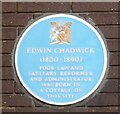
Edwin Chadwick (1800 - 1890)
The blue plaque on the wall of a house on Stockport Road Image reads: EDWIN CHADWICK (1800 - 1890) POOR LAW AND SANITARY REFORMER AND ADMINISTRATOR WAS BORN IN A COTTAGE ON THIS SITE
Image: © Gerald England Taken: 26 Mar 2022
0.12 miles
  • ...