IMAGES TAKEN NEAR TO
Dobcross Close, MANCHESTER, M13 0GQ
Introduction
This page details the photographs taken nearby to Dobcross Close, M13 0GQ by members of the Geograph project.
The Geograph project started in 2005 with the aim of publishing, organising and preserving representative images for every square kilometre of Great Britain, Ireland and the Isle of Man.

There are currently over 7.5m images from over14,400 individuals and you can help contribute to the project by visiting https://www.geograph.org.uk
Image Map
Images are licensed for reuse under creativecommons.org/licenses/by-sa/2.0
Notes
- Clicking on the map will re-center to the selected point.
- The higher the marker number, the further away the image location is from the centre of the postcode.
Image Listing (50 Images Found)
Images are licensed for reuse under creativecommons.org/licenses/by-sa/2.0
Image
Details
Distance
2
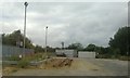
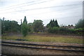
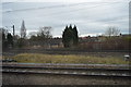
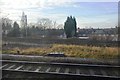
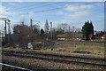
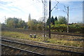
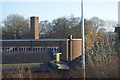
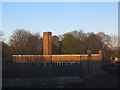
Land between railways, Levenshulme
The gravelled area is set in the narrowing space between the main line and the loop via Styal and Alderley Edge.
Image: © Christopher Hilton
Taken: 25 Jul 2013
0.03 miles
9
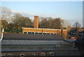
Beth Shan church, Crowcroft Road, Levenshulme
An Assemblies of God Pentecostal church. According to their website http://www.bethshan-revival.org the building dates from 1928 although the congregation grew out of a revival in 1917.
Image: © Stephen Craven
Taken: 17 Apr 2016
0.06 miles