IMAGES TAKEN NEAR TO
Hathersage Road, MANCHESTER, M13 0EW
Introduction
This page details the photographs taken nearby to Hathersage Road, M13 0EW by members of the Geograph project.
The Geograph project started in 2005 with the aim of publishing, organising and preserving representative images for every square kilometre of Great Britain, Ireland and the Isle of Man.

There are currently over 7.5m images from over14,400 individuals and you can help contribute to the project by visiting https://www.geograph.org.uk
Image Map
Images are licensed for reuse under creativecommons.org/licenses/by-sa/2.0
Notes
- Clicking on the map will re-center to the selected point.
- The higher the marker number, the further away the image location is from the centre of the postcode.
Image Listing (99 Images Found)
Images are licensed for reuse under creativecommons.org/licenses/by-sa/2.0
Image
Details
Distance
1
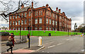
Manchester Metropolitan University
The Elizabeth Gaskell Building at Manchester Metropolitan University.
Image: © Peter McDermott
Taken: 22 Nov 2015
0.07 miles
2
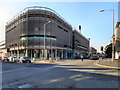
The Hathersage Centre
Large, modern, NHS health centre on Upper Brook Street in Manchester.
Image: © David Dixon
Taken: 28 Sep 2011
0.08 miles
3
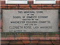
Elizabeth Gaskell Building (memorial stone)
The memorial stone set in the wall of Image] when it opened as "the Manchester College of Domestic Science" in 1912.
Image: © David Dixon
Taken: 28 Sep 2011
0.09 miles
4
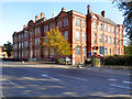
Manchester Metropolitan University, Elizabeth Gaskell Building
The University's Elizabeth Gaskell campus on Hathersage Road.
Opened in 1912 (Image]) as "The Manchester College of Domestic Science", the building later became "The Elizabeth Gaskell College of Education" in the early 1960s. In 1982, as a cost cutting measure, the college was absorbed by Manchester Polytechinc which later became the Manchester Metropolitan University. (http://yourarchives.nationalarchives.gov.uk/index.php?title=Elizabeth_Gaskell_College_of_Education_Manchester - Your Archives)
Image: © David Dixon
Taken: 28 Sep 2011
0.10 miles
5
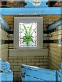
Changing Cubicle With 'Lily' Window, Victoria Baths
Image: © David Dixon
Taken: 30 Apr 2014
0.10 miles
6
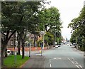
Anson Road/Upper Brook Street
The A34 towards Manchester. At the crossroads Anson Road changes into Upper Brook Street. Left is Oxford Place, right is Daisybank Road.
Image: © Gerald England
Taken: 2 Aug 2010
0.10 miles
7
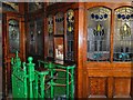
Ticket Office and Turnstile, Males 1st Class Entrance at Victoria Baths
Image: © David Dixon
Taken: 30 Apr 2014
0.10 miles
8
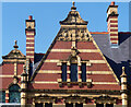
Detail of Victoria Baths, Hathersage Road, Manchester (2)
Showing the terracotta detail and essential stripiness of the building: Image
Image: © Stephen Richards
Taken: 17 Aug 2016
0.10 miles
9

Sunrise Window, Turkish Baths Rest Room
The Turkish Rest Room is one of the most memorable spaces at Victoria Baths. It is tiled from floor to ceiling and has four unique stained glass windows depicting sunrise, noon and evening, as well as the famous Angel of Purity.
Image: © David Dixon
Taken: 30 Apr 2014
0.10 miles
10
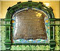
Commemorative Plaque, Manchester Victoria Baths
Plaque commemorating the opening of the Victoria Baths on September 7th 1906 by the Lord Mayor. As was the practice at the time, the plaque lists not only the Mayor , who opened the baths, but also the other members of the "Baths & Wash Houses Committee" (who presumably came to witness the proceedings).
The plaque is just inside the doorway to the Males 1st Class entrance.
Image: © David Dixon
Taken: 30 Apr 2014
0.10 miles