IMAGES TAKEN NEAR TO
Plymouth Grove West, MANCHESTER, M13 0AQ
Introduction
This page details the photographs taken nearby to Plymouth Grove West, M13 0AQ by members of the Geograph project.
The Geograph project started in 2005 with the aim of publishing, organising and preserving representative images for every square kilometre of Great Britain, Ireland and the Isle of Man.

There are currently over 7.5m images from over14,400 individuals and you can help contribute to the project by visiting https://www.geograph.org.uk
Image Map
Images are licensed for reuse under creativecommons.org/licenses/by-sa/2.0
Notes
- Clicking on the map will re-center to the selected point.
- The higher the marker number, the further away the image location is from the centre of the postcode.
Image Listing (38 Images Found)
Images are licensed for reuse under creativecommons.org/licenses/by-sa/2.0
Image
Details
Distance
1
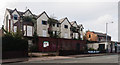
Longsight
Derelict buildings on the A6, Stockport Road, in Longsight.
Image: © Peter McDermott
Taken: 1 Nov 2014
0.06 miles
2
Chadwick Place
A new development on Stockport Road.
Image: © Peter McDermott
Taken: 10 Oct 2021
0.06 miles
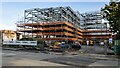
3

328-336 Stockport Road
Demolition and ground works at the new development site, 328-336 Stockport Road.
Image: © Peter McDermott
Taken: 7 Feb 2021
0.06 miles
5
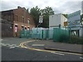
Plymouth Grove West is blocked off
It has a compound erected on the Stockport Road end. This is slightly inconvenient as it is a useful route through to Hathersage Road.
Image: © Bill Boaden
Taken: 9 Jun 2015
0.07 miles
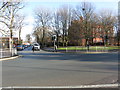
6
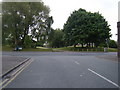
Stockport Road/ Hathersage Road junction
Image: © Colin Pyle
Taken: 21 May 2010
0.08 miles

8
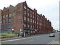
Daisy Works in Stockport Road, Longsight
Originally a cotton mill, the Daisy Mill suffered a fire in 1928 but the damage was repaired and it continued to operate until 1939. During WWII the mill was used by the War Office as an Army Pay Corps Depot. After the war the building once again returned to commerce in the garment industry. Many local women were employed as machinists. Parts of the building are still used by small businesses and some council services but currently (Nov 2015) a process is underway that will lead to the demolition of the mill. The plan is to use the site for a new secondary school, part of the Dean Trust.
Image: © Rod Allday
Taken: 12 Apr 2014
0.09 miles
9

Longsight
New houses on the A6, Stockport Road in Longsight.
Image: © Peter McDermott
Taken: 17 Apr 2017
0.09 miles
10

Longsight
New development in Longsight.
Image: © Peter McDermott
Taken: 6 Aug 2016
0.10 miles