IMAGES TAKEN NEAR TO
Chapeltown Street, MANCHESTER, M1 2WH
Introduction
This page details the photographs taken nearby to Chapeltown Street, M1 2WH by members of the Geograph project.
The Geograph project started in 2005 with the aim of publishing, organising and preserving representative images for every square kilometre of Great Britain, Ireland and the Isle of Man.

There are currently over 7.5m images from over14,400 individuals and you can help contribute to the project by visiting https://www.geograph.org.uk
Image Map (Loading...)


Getting Data...Please wait
Leaflet Map data © OpenStreetMap
Images are licensed for reuse under creativecommons.org/licenses/by-sa/2.0
Notes
- Clicking on the map will re-center to the selected point.
- The higher the marker number, the further away the image location is from the centre of the postcode.
Image Listing (1106 Images Found)
Images are licensed for reuse under creativecommons.org/licenses/by-sa/2.0
Image
Details
Distance
1
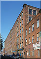
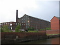
Crusader Works, Chapeltown Street, Manchester
A former mid-C19th mill complex with a relentless twenty-eight-bay facade to the street. It has an internal courtyard and a chimney survives. Grade II listed.
Now converted to small light-industrial units, many of whose occupants seem to be artists or clothing-related (Image]).
Image: © Stephen Richards
Taken: 24 Jul 2011
0.00 miles
2
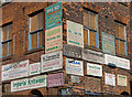
Detail of Crusader Works, Chapeltown Street, Manchester
A cluster of signs on the corner of this former mill Image], all advertising clothing-related manufacturers. Many of them look dated and hence may not be current.
Image: © Stephen Richards
Taken: 24 Jul 2011
0.01 miles
3
Baird Street
Warehouses and industrial buildings on Baird Street in Manchester.
Image: © Peter McDermott
Taken: 17 May 2015
0.02 miles
4
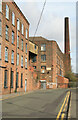
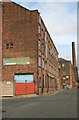
Chapeltown Street Mills, Manchester
Seen from Baird Street. Identified from RCHME gazetteer with help of grid reference. I know nothing about these mills. They are in multiple occupancy and have decidedly rough edges.
Image: © Chris Allen
Taken: 2 Mar 2008
0.02 miles
5
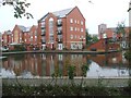
Piccadilly Village - Thomas Telford Basin
A 1990 housing development near Piccadilly Station.
Image: © John M
Taken: 11 Oct 2011
0.03 miles
6
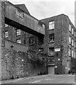
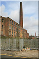
Chapeltown Street Mills
Identified from RCHME gazetteer with help of grid reference. I know nothing about these mills. They are in multiple occupancy and have decidedly rough edges.
Image: © Chris Allen
Taken: 2 Mar 2008
0.03 miles
7
Chapeltown Street Mills, Manchester
Identified from RCHME gazetteer with help of grid reference. I know nothing about these mills. They are in multiple occupancy and have decidedly rough edges. I think a tram line has been put through close to where I was stood in 2008
Image: © Chris Allen
Taken: 2 Mar 2008
0.03 miles
8
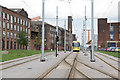
Piccadilly turn-back
Trams which terminate at Piccadilly Station continue through the station to this siding between the main running lines where they can wait before starting their next journey. Behind are former textile mills typical of the Ancoats district of Manchester.
Image: © Alan Murray-Rust
Taken: 7 Aug 2013
0.03 miles
9
Sankey's Stores
The name is still visible on this old mill, viewed from the Ashton Canal bank near the A665 bridge
Image: © Keith Edkins
Taken: 28 Jun 2006
0.04 miles
10
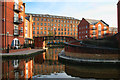
Piccadilly Village
The Piccadilly Village development in Manchester.
Image: © Peter McDermott
Taken: 6 Apr 2013
0.04 miles