IMAGES TAKEN NEAR TO
Baring Street Industrial Estate, MANCHESTER, M1 2PZ
Introduction
This page details the photographs taken nearby to Baring Street Industrial Estate, M1 2PZ by members of the Geograph project.
The Geograph project started in 2005 with the aim of publishing, organising and preserving representative images for every square kilometre of Great Britain, Ireland and the Isle of Man.

There are currently over 7.5m images from over14,400 individuals and you can help contribute to the project by visiting https://www.geograph.org.uk
Image Map
Images are licensed for reuse under creativecommons.org/licenses/by-sa/2.0
Notes
- Clicking on the map will re-center to the selected point.
- The higher the marker number, the further away the image location is from the centre of the postcode.
Image Listing (1061 Images Found)
Images are licensed for reuse under creativecommons.org/licenses/by-sa/2.0
Image
Details
Distance
2
Escape to Freight Island
Part of Depot Mayfield, Escape to Freight Island is a restaurant space inside the former freight depot at Mayfield Station. On the outside it describes itself as "A haven for heathens, hoodies and hipsters, hijabis and high brow intellectuals and however you sexuals". On the right is an entrance to newly created Mayfield Park.
Image: © Gerald England
Taken: 1 Oct 2022
0.02 miles
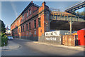
3
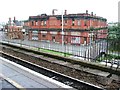
Manchester, Baring Street
The high rise building on the left is called Piccadilly Point. It is student accommodation.
Image: © David Dixon
Taken: 29 Feb 2020
0.02 miles
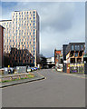
4
The view from platform 14
Looking across Fairfield Street from platform 14 at Piccadilly Station.
In the centre is the former Mayfield Station which finally seems to finding itself a new purpose. On the left is the Grade II listed https://historicengland.org.uk/listing/the-list/list-entry/1200827 Star & Garter whose future seems still a little uncertain. On the right is Piccadilly Point https://www.unitestudents.com/manchester/piccadilly-point student accommodation run by Unite Students.
Image: © Gerald England
Taken: 23 Aug 2017
0.02 miles
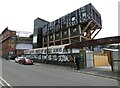
5
Manchester Mayfield railway station (site)
Opened in 1910 as an overflow station for London Road station (now Piccadilly) by the London & North Western Railway, this station was closed to passengers in 1960. It was used as a goods station until 1986 but by the time this image was taken, had lain derelict for many years.
Image: © Nigel Thompson
Taken: 19 Jul 2008
0.02 miles
6

Christmas at the gentrified Mayfield Station
Image: © Anthony Parkes
Taken: 30 Nov 2022
0.03 miles
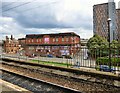
7
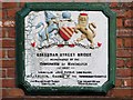
Boardman Street Bridge
The bridge over the River Medlock at Baring Street (Image]) carries this plaque making the reconstruction of the Boardman Street Bridge in 1907. The street is shown on maps as "Baring Street" - perhaps it used to be called "Boardman Street".
Image: © David Dixon
Taken: 5 Feb 2014
0.03 miles
8
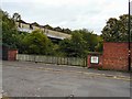
A Bit of Hidden Manchester
Behind this bridge over the River Medlock on Baring Street is the remains of the disused Mayfield station.
The plate on the bridge refers to it as Boardman Street bridge Image
Image: © Gerald England
Taken: 14 Aug 2009
0.03 miles
9
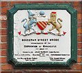
Boardman Street Bridge
Plaque commemorating the reconstruction of the Boardman Street Bridge by the Corporation of Manchester in 1907.
Signs and street maps name it Baring Street. Image An internet search for Boardman Street only revealed a reference to Boardman Street in this area in a 19th century census.
Image: © Gerald England
Taken: 14 Aug 2009
0.03 miles
10
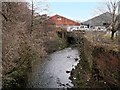
River Medlock
The River Medlock behind the site of the former Mayfield Station (Image]). Viewed from Baring Street.
Image: © David Dixon
Taken: 5 Feb 2014
0.03 miles