IMAGES TAKEN NEAR TO
London Road, MANCHESTER, M1 2PH
Introduction
This page details the photographs taken nearby to London Road, M1 2PH by members of the Geograph project.
The Geograph project started in 2005 with the aim of publishing, organising and preserving representative images for every square kilometre of Great Britain, Ireland and the Isle of Man.

There are currently over 7.5m images from over14,400 individuals and you can help contribute to the project by visiting https://www.geograph.org.uk
Image Map
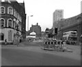
Images are licensed for reuse under creativecommons.org/licenses/by-sa/2.0
Notes
- Clicking on the map will re-center to the selected point.
- The higher the marker number, the further away the image location is from the centre of the postcode.
Image Listing (1746 Images Found)
Images are licensed for reuse under creativecommons.org/licenses/by-sa/2.0
Image
Details
Distance
1
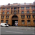
Inscription above the entrance to the old fire station, London Road, Manchester
The inscription at the top of the building is ERECTED ANNO DOMINI MDCCCCV.
The Roman numerals MDCCCCV = 1905. The fire station http://www.geograph.org.uk/photo/5220131 opened in 1906,
was Grade II (star) listed in 1974 and ceased to be a fire station in 1986.
Image: © Jaggery
Taken: 10 Sep 2016
0.00 miles
2
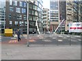
Footbridge over London Road
Outside Manchester Piccadilly station.
Image: © Stephen Sweeney
Taken: 7 Apr 2009
0.01 miles
3
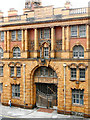
Fire Station Entrance, London Road
London Road Fire Station occupies a site bounded by London Road, Whitworth Street, Minshull Street South and Fairfield Street. It was opened in 1906 and, In addition to a fire station, the building also housed a police station, an ambulance station, a bank, a Coroner's Court, and a gas-meter testing station.
The fire station closed in 1986, since when it has been largely unused despite several redevelopment proposals. It is a Grade II* listed building.
More information at http://en.wikipedia.org/wiki/London_Road_Fire_Station,_Manchester Wikipedia
Image: © David Dixon
Taken: 4 Sep 2012
0.01 miles
4

The old fire station which closed in 1985 and has been vacant since
Image: © Ian Greig
Taken: 18 Jan 2015
0.01 miles
5
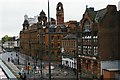
Former police station and fire station, London Road
Image: © Christopher Hilton
Taken: 24 Oct 2009
0.01 miles
6

NW corner dome of Old Fire Station
Detail of the dome at the NW corner of the Old Fire Station on London Road.
Image: © Gerald England
Taken: 2 Mar 2013
0.01 miles
7
London Road, Manchester
Looking north west. The Metrolink tracks will sweep across the road to the right to enter the undercroft of Piccadilly station at a point slightly in front of where the bus is standing.
Image: © Dr Neil Clifton
Taken: 12 Apr 1991
0.01 miles
8
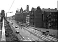
London Road, Manchester
Looking south east from Piccadilly station approach
Image: © Dr Neil Clifton
Taken: 12 Apr 1991
0.01 miles
9
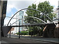
Footbridge to Piccadilly Station, Manchester
Designed by Wilkinson Eyre, the footbridge is also known as the Manchester Curve. It links Piccadilly Place to Manchester Piccadilly Station.
Image: © Richard Rogerson
Taken: 15 Jul 2009
0.01 miles
10

London Road
Note the old Cartage & Goods building Image
Image: © Thomas Nugent
Taken: 10 Nov 2014
0.01 miles