IMAGES TAKEN NEAR TO
Travis Street, MANCHESTER, M1 2NG
Introduction
This page details the photographs taken nearby to Travis Street, M1 2NG by members of the Geograph project.
The Geograph project started in 2005 with the aim of publishing, organising and preserving representative images for every square kilometre of Great Britain, Ireland and the Isle of Man.

There are currently over 7.5m images from over14,400 individuals and you can help contribute to the project by visiting https://www.geograph.org.uk
Image Map (Loading...)


Getting Data...Please wait
Leaflet Map data © OpenStreetMap
Images are licensed for reuse under creativecommons.org/licenses/by-sa/2.0
Notes
- Clicking on the map will re-center to the selected point.
- The higher the marker number, the further away the image location is from the centre of the postcode.
Image Listing (444 Images Found)
Images are licensed for reuse under creativecommons.org/licenses/by-sa/2.0
Image
Details
Distance
1
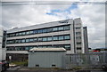
Aeroworks Building
The Aeroworks building on Adair Street is a former aircraft components factory converted by the architectural practice of Stephenson Bell. The converted office building became Stephenson Bell's office and the other occupants have included the Royal Institute for the Deaf.
Image: © Peter McDermott
Taken: 1 Sep 2017
0.06 miles
2
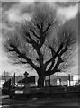
St Andrews Street
Tree in the grounds of the demolished St Andrews Church.
Image: © Peter McDermott
Taken: 31 Dec 2021
0.06 miles
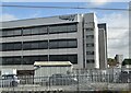
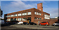
5
St. Andrew's Street
Network Rail/Square One Office building in view.
Image: © John Topping
Taken: 13 Mar 2013
0.09 miles