IMAGES TAKEN NEAR TO
Dale Street, MANCHESTER, M1 2HF
Introduction
This page details the photographs taken nearby to Dale Street, M1 2HF by members of the Geograph project.
The Geograph project started in 2005 with the aim of publishing, organising and preserving representative images for every square kilometre of Great Britain, Ireland and the Isle of Man.

There are currently over 7.5m images from over14,400 individuals and you can help contribute to the project by visiting https://www.geograph.org.uk
Image Map (Loading...)


Getting Data...Please wait
Leaflet Map data © OpenStreetMap
Images are licensed for reuse under creativecommons.org/licenses/by-sa/2.0
Notes
- Clicking on the map will re-center to the selected point.
- The higher the marker number, the further away the image location is from the centre of the postcode.
Image Listing (2419 Images Found)
Images are licensed for reuse under creativecommons.org/licenses/by-sa/2.0
Image
Details
Distance
1
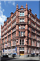
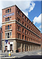
35 Dale Street, Manchester
An imposing, and quite pink, former warehouse whose angles are embellished by octagonal turrets culminating in pinnacles. Built 1903 by J.W. Beaumont. Grade II listed.
The listing records that it was "occupied in 1905 by Richard Howarth & Co, cotton spinners and manufacturers". It has now been converted into offices.
Image: © Stephen Richards
Taken: 23 Jul 2011
0.01 miles
2
Tariff and Dale
A pub on the corner of Tarrif Street and Dale Street. A former warehouse dating from the mid 19th century. A grade II listed building, see https://historicengland.org.uk/listing/the-list/list-entry/1283061 .
See also Image and Image
Image: © Bob Harvey
Taken: 24 May 2022
0.02 miles
3
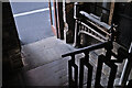
Weighbridge at the door
19th century balance-beam weighing machine at the door of Image
Image: © Bob Harvey
Taken: 24 May 2022
0.02 miles
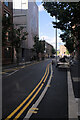
4
Port Street and Newton Street
Port Street is to the right, Newton Street to the left.
Image: © Thomas Nugent
Taken: 28 Feb 2011
0.02 miles
5

Interior of converted warehouse
The pub seen in Image is furnished in the inevitable "ex-industrial chic" style, emphasising the building's former use.
Image: © Bob Harvey
Taken: 24 May 2022
0.02 miles
6
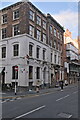
Bradley House, Dale Street, Manchester
A stately former warehouse which for its date, c1850, is remarkably restrained. There is scarcely a decorative flourish in sight, just a rusticated stone ground floor, cornice and tripartite window. It is definitely infused with the spirit of the Georgians rather than the Victorians. Grade II listed.
It has been converted into offices, being marketed, when I visited, as "The Flatiron".
Image: © Stephen Richards
Taken: 23 Jul 2011
0.02 miles
7
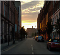
Tariff Street
View looking up Tariff Street from Dale Street.
Image: © Peter McDermott
Taken: 19 Jul 2018
0.02 miles
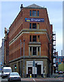
9

Inhuman barriers
"Inhuman barriers" is the name of this mural on the side of Hilton House. It was created by Swiss art collective Nevercrew (Pablo Togni and Christian Rebecchi). It depicts the fate of immigrants falling from the structure of society.
See https://nevercrew.com/inhuman-barries
Hilton House itself is interesting, being one of the very first 1960s office blocks built in the former industrial Northern Quarter, and recently undergoing restoration. See https://www.manchestereveningnews.co.uk/news/greater-manchester-news/gallery/inside-hilton-house-northern-quarter-16956649 for a well-written account of the building.
Image: © Bob Harvey
Taken: 24 May 2022
0.02 miles
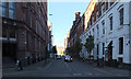
10
Tariff Street
Showing the location of the mural Image on Hilton House.
Image: © Bob Harvey
Taken: 24 May 2022
0.02 miles