IMAGES TAKEN NEAR TO
Ducie Street, MANCHESTER, M1 2DP
Introduction
This page details the photographs taken nearby to Ducie Street, M1 2DP by members of the Geograph project.
The Geograph project started in 2005 with the aim of publishing, organising and preserving representative images for every square kilometre of Great Britain, Ireland and the Isle of Man.

There are currently over 7.5m images from over14,400 individuals and you can help contribute to the project by visiting https://www.geograph.org.uk
Image Map
Images are licensed for reuse under creativecommons.org/licenses/by-sa/2.0
Notes
- Clicking on the map will re-center to the selected point.
- The higher the marker number, the further away the image location is from the centre of the postcode.
Image Listing (1925 Images Found)
Images are licensed for reuse under creativecommons.org/licenses/by-sa/2.0
Image
Details
Distance
1
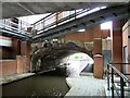
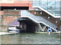
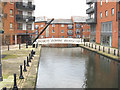
Ashton Canal Bridge #1
Bridge #1 carries Ducie Street over the canal. Beyond the bridge is the Rochdale Canal. Apartments and offices line the sides the canal with footbridges crossing it. Just off the towpath in the shelter of the buildings are the homes of many "rough sleepers". I must have passed at least half a dozen including one sleeping dog following the towpath from under bridge #2. I kept my camera out of sight.
Image: © Gerald England
Taken: 8 Aug 2014
0.00 miles
2
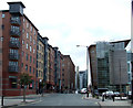
Ducie Street
Navigation House is on the right.
Image: © Thomas Nugent
Taken: 2 Apr 2013
0.01 miles
4
Ashton Canal, Bridge#1 (Ducie Street Bridge)
This bridge is at the exit of the Ashton Canal where it joins the Rochdale Canal at Piccadilly Basin.
Image: © David Dixon
Taken: 2 Oct 2012
0.01 miles
5
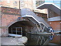
The Rochdale Canal
The arch leads to the Ashton Canal.
Image: © Thomas Nugent
Taken: 28 Jan 2013
0.01 miles
6
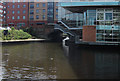
Ashton Canal meets Rochdale Canal
The Ashton Canal passes under the bridge centre of shot. This junction is adjacent to Dale Street NCP car park near Piccadilly railway station.
Image: © michael ely
Taken: 16 May 2014
0.01 miles
7
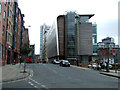
Ducie Street
Navigation House is on the right.
Image: © Thomas Nugent
Taken: 2 Apr 2013
0.01 miles
8
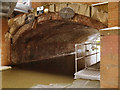
The Ashton Canal
The basin at the west end of the canal, near Piccadilly railway station. Viewed from the Jutland Street bridge. The branch on the right, passes under Ducie Street to connect to the Rochdale Canal.
Image: © Thomas Nugent
Taken: 2 Apr 2013
0.01 miles
9
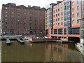
Manchester: Paradise Wharf, Ashton Canal
The main line of the Ashton Canal runs across the bottom of the picture beyond the footbridge. At the near end, the basin is a 'dead end'.
Image: © Dr Neil Clifton
Taken: 8 Feb 2010
0.02 miles
10
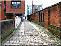
Manchester: Old paving alongside Ducie Street
Across the head of Paradise Wharf, this half-bridge separates it from Ducie Street, with old paving that may date back to the canal era.
Image: © Dr Neil Clifton
Taken: 8 Feb 2010
0.02 miles