IMAGES TAKEN NEAR TO
Blakemore Walk, MANCHESTER, M12 6PH
Introduction
This page details the photographs taken nearby to Blakemore Walk, M12 6PH by members of the Geograph project.
The Geograph project started in 2005 with the aim of publishing, organising and preserving representative images for every square kilometre of Great Britain, Ireland and the Isle of Man.

There are currently over 7.5m images from over14,400 individuals and you can help contribute to the project by visiting https://www.geograph.org.uk
Image Map (Loading...)


Getting Data...Please wait
Leaflet Map data © OpenStreetMap
Images are licensed for reuse under creativecommons.org/licenses/by-sa/2.0
Notes
- Clicking on the map will re-center to the selected point.
- The higher the marker number, the further away the image location is from the centre of the postcode.
Image Listing (74 Images Found)
Images are licensed for reuse under creativecommons.org/licenses/by-sa/2.0
Image
Details
Distance
3
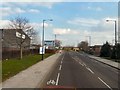
Ashton New Road
The A662 from Manchester to Droylsden approaching Councillor Street (viewed from the top deck of a bus).
Image: © Gerald England
Taken: 1 Mar 2012
0.09 miles
4
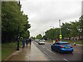
Ashton New Road
Safe walking route from city centre to the Ethiad complex.
Image: © Steve Fareham
Taken: 25 May 2016
0.09 miles
5
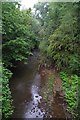
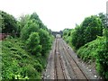
Medlock River
Taken from a footbridge looking upstream
Image: © Glyn Baker
Taken: 30 Aug 2019
0.13 miles
6

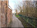
Medlock Valley Way Cycle Path
Part of the national cycle route network
Image: © Glyn Baker
Taken: 30 Aug 2019
0.13 miles
7
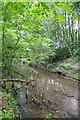
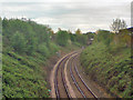
Looking Upstream on The Medlock
A scrap of green in urban Manchester
Image: © Glyn Baker
Taken: 30 Aug 2019
0.14 miles